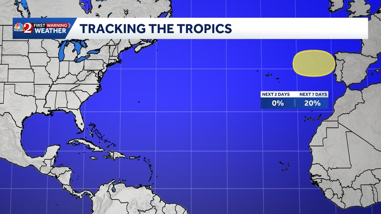
The National Hurricane Center (NHC) announced Thursday that it is monitoring a new area of interest in the Atlantic Ocean. The system, described as a non‑tropical low‑pressure area, is situated along a frontal boundary in the northeastern Atlantic and is expected to evolve early Friday.
Potential development and movement
Forecasters note that the low could detach from its surrounding fronts and acquire subtropical or even tropical characteristics over the weekend. If such a transition occurs, the system would join the ongoing 2026 Atlantic hurricane season, which already features several named storms.
Current model guidance shows the low moving generally eastward or east‑northeastward, with a trajectory that could bring it toward the coasts of Portugal and Spain. While the system is still far from land, its projected path has prompted early preparedness advisories in the affected European regions.
Formation probabilities
The NHC provided quantitative outlooks for the system’s development:
- 0 percent chance of formation within the next 48 hours.
- 20 percent chance of development over the next seven days.
These percentages reflect the inherent uncertainty in forecasting systems that are still in the early stages of organization. Meteorologists will continue to monitor satellite imagery, surface observations, and model trends to refine the outlook.
Implications for the 2026 hurricane season
Although the Atlantic basin is currently experiencing an active season, the emergence of a new low‑pressure area underscores the need for ongoing vigilance. Residents of the Gulf Coast, the Eastern Seaboard, and Caribbean islands are reminded to stay informed through official channels, including local National Weather Service offices and the NHC’s official website.
In Central Florida, the First Warning Weather team at WESH 2 continues to provide up‑to‑date forecasts and alerts. Viewers can follow the team’s coverage online or via the WESH 2 News app, which offers real‑time weather notifications for the region.
What to watch
Key factors that will influence the system’s evolution include sea‑surface temperatures, atmospheric moisture, and wind shear. Favorable conditions could accelerate the transition to a subtropical or tropical cyclone, while unfavorable conditions could cause the low to dissipate without further development.
For now, the NHC advises mariners, coastal residents, and aviation operators to remain alert to any changes in the system’s intensity or track. Updated advisories will be issued as new data become available.
Staying prepared
Even though the low‑pressure area is currently far from the United States, the broader lesson remains clear: preparedness saves lives. Households should review emergency kits, ensure communication plans are in place, and stay tuned to trusted weather sources throughout the hurricane season.
Original reporting: WESH Orlando — read the source article.