A medical transport aircraft that crashed in the Capitan Mountains, northeast of Ruidoso, New Mexico, experienced a loss of GPS navigation capability shortly before the accident, according to a preliminary report released by the National Transportation Safety Board.
Crash Details
The aircraft, operated by Generations Jets as an air ambulance flight, crashed shortly after midnight on May 14 while transporting two flight nurses to Sierra Blanca Regional Airport in Ruidoso to pick up a patient. Both pilots and both medical crew members were killed.
About eight minutes into the flight, air traffic controllers advised the crew that the aircraft had climbed 1,000 feet above its assigned altitude. The pilot responded that the airplane had lost GPS capability and requested heading assistance from controllers.
Military GPS-jamming operations were active across a large portion of New Mexico during the time of the flight. Air traffic controllers subsequently contacted military personnel and requested that the jamming be halted after multiple aircraft in the region reported GPS-related issues.
Flight tracking data showed the aircraft continuing toward the mountainous terrain northeast of Ruidoso while maintaining an altitude of roughly 12,600 feet.
At approximately 12:08 a.m., the crew twice reported having Ruidoso in sight and requested a visual approach. Air traffic control cleared the aircraft for a visual approach to Sierra Blanca Regional Airport. The crew acknowledged the clearance and indicated they expected to cancel their IFR flight plan within a few minutes.
No further communications were received from the aircraft.
Investigators said the airplane turned southwest toward the airport and began descending. Between the aircraft and the airport lay the Capitan Mountains, a rugged mountain range with peaks exceeding 10,000 feet in elevation.
Around 12:10 a.m., after being informed that the aircraft was conducting a visual approach, military officials were advised they could resume GPS-jamming operations, according to the report.
Flight tracking data showed the aircraft descending to approximately 9,400 feet before beginning a brief climb. The last recorded position showed the airplane traveling at about 150 knots on a southwest heading.
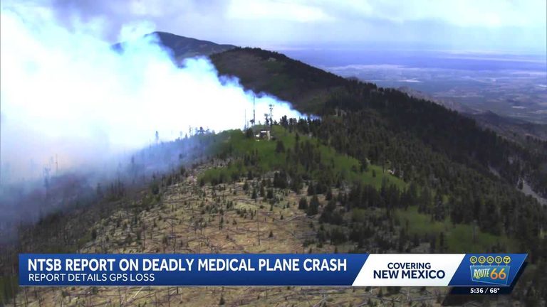
The aircraft struck terrain at an elevation of approximately 9,950 feet near the summit of the Capitan Mountains.
The impact destroyed the aircraft and sparked a wildfire in the surrounding forest.
The NTSB report also noted that pilots had received notices warning that GPS service could be unavailable due to military testing and training activities. The notices indicated GPS disruptions could affect navigation systems across a broad region.
In addition, Sierra Blanca Regional Airport’s Automated Weather Observing System was out of service at the time of the flight. Weather briefing materials available to the crew indicated that no automated weather observations or terminal forecasts were available for the airport.
The NTSB emphasized that the findings are preliminary and subject to change as investigators continue examining the circumstances surrounding the crash.
A final report identifying the probable cause of the accident is expected at a later date.
Original reporting: KOAT Albuquerque — read the source article.


