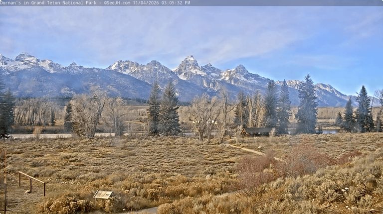
Jackson, Wyoming – The Tetons experienced an unusually warm and moist October, followed by a November that is shaping up mild and dry. Residents can expect continued above‑average temperatures early in the month, with only a slight chance of snow.
October 2026 Review
Temperatures throughout October were well above normal, making the month the warmest since 2015. Early in the month, a strong ridge of high pressure produced summer‑like conditions, with the Jackson weather station recording highs of 80°F on October 4 and 82°F on October 5 – the first 80°F days in October since 2010.
Mid‑month, a low‑pressure system carrying moisture from the remnants of Tropical Storm Rachel delivered substantial rain. Jackson saw a four‑day total of 1.9 inches, while the Tetons received 2–3.5 inches of rain and 1–3 inches of snow at elevations above 8,000 feet.
After a brief dry spell, additional rain fell from October 22‑24, producing 0.75–1.25 inches of precipitation. The final week of the month brought light rain to the valley and light snow to higher elevations on October 27‑28.
Overall, Jackson recorded 2.96 inches of rain – just shy of 3 inches – making it the wettest October since 2016, though well below the 5‑inch total of that year. Snowfall was scarce: the town logged only a trace on October 28, and the Rendezvous Bowl Plot recorded 13 inches of snow, matching its monthly average and ranking as the fourth‑least snowy October in 30 years.
Current Weather Pattern
A slow‑moving low‑pressure system recently crossed the Southern Rockies, pulling subtropical moisture into the area. While the system added rain at lower elevations (0.5–1.5 inches from Friday night to Monday morning), snow remained confined to elevations above 9,000 feet, with 2–6 inches falling on the higher Tetons.
Highs this week have hovered in the 40s‑50s in the valley, with overnight lows in the 20s‑30s. Cloud cover has prevented a valley freeze on several consecutive mornings.
November Outlook
For the first half of November, the forecast calls for mild, dry conditions. A ridge of high pressure will dominate the Interior West, bringing sunshine and daytime highs well into the 50s and occasionally the low 60s. Overnight lows are expected to dip into the upper teens to low 20s in the valley.
Snow potential remains limited through November 12‑13, though a more active pattern may arrive around mid‑month. Confidence is high that temperatures will stay above average, though precipitation outlooks are mixed, with an even chance of above‑ or below‑average totals. Given the slow start and warm early temperatures, a below‑average snowfall for the month is the more likely scenario.
Historically, strong east‑based El Niño winters like this one tend to start slowly in November‑December, then pick up strength in the January‑March period. Residents should monitor upcoming forecasts for any shifts in the pattern.
What This Means for Residents
Winter recreation may be delayed as snowpack builds later than usual. However, the continued dry spell reduces the risk of early‑season flooding and eases travel conditions on mountain roads. Those planning outdoor activities should stay tuned to short‑term forecasts, especially for any late‑month moisture spikes.
Original reporting: Buckrail (Jackson WY) — read the source article.