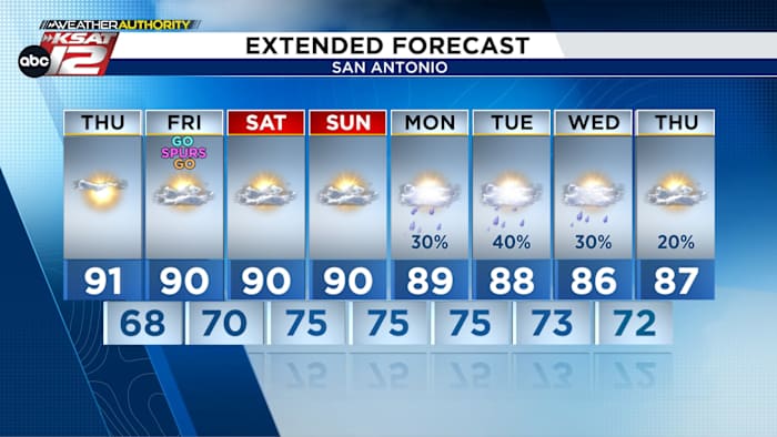
A fast-read look at what’s coming: a warm day with highs near 90, a humid and sticky weekend with morning clouds and a chance of drizzle, then storm chances returning Monday through Wednesday with isolated to scattered storms and the potential for severe weather. Expect morning cloud cover on Friday through Sunday, afternoon sunshine, and the usual precautions for heat and sudden storms. This forecast covers the upcoming stretch from today into next week across the region.
Today starts mild and quickly warms up into a toasty afternoon. Most spots will climb to around 90 degrees under mostly sunny skies, so plan outdoor plans with that in mind. Lighter winds will let the heat pile up in the afternoon, making it feel like a classic late-spring day.

Humidity is on the move and will be noticeable by Friday, setting the stage for a sticky weekend. Morning clouds will linger Friday, Saturday, and Sunday, and by Sunday you could see some light drizzle or sprinkles in patches. Each afternoon should break into sunshine with temperatures still hovering near 90 degrees despite the added moisture in the air.

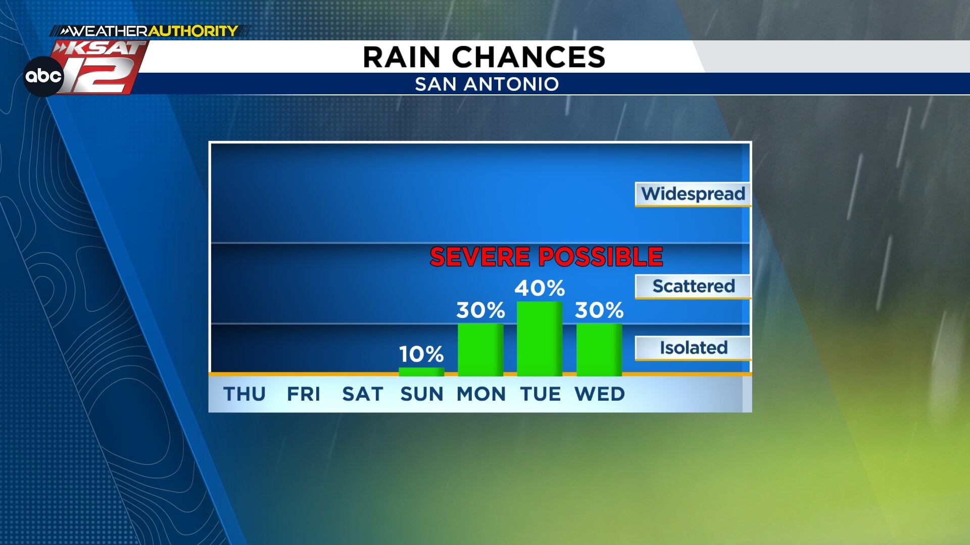
Storm chances return to the forecast starting Monday, with activity beginning isolated and becoming more scattered by Tuesday. A slim chance of rain lingers into Wednesday, and any of those days could produce severe storms in pockets. Keep an eye on evolving radar trends early next week as small changes in timing and placement will decide who sees the stronger storms.
With the humidity rising this weekend, the heat will feel heavier than the thermometer suggests, especially in the afternoon and early evening. Hydration matters more than ever and consider limiting strenuous outdoor activities during peak sun hours. If you have pets or yard plans, move them to cooler times of the day to avoid the worst of the stickiness.
The severe potential next week centers on strong winds and hail, though brief tornadoes can’t be ruled out in any setup that favors rotation. Storms that tap into the moist air mass will have the fuel to intensify quickly, so rapid development is possible. Make sure your phone alerts are enabled and you know your safest place in the home if warnings are issued.
Practical reminders for the coming days: charge devices, check generators if you have them, and have a simple emergency kit ready in case severe storms cut power for a time. Plan outdoor events around morning hours or late afternoons when storms are less likely, and keep a lightweight rain jacket handy for sudden showers. Businesses and schools should have basic weather plans reviewed with staff so responses are quick if conditions shift.
Here are the quick tools to keep handy as the pattern changes this weekend into next week:
- WATCH LIVE: Doppler Radar
- Hourly and 10-Day Forecast
- Download FREE Weather App: Up-to-date forecasts and livestreams from local meteorologists
- Share Your Weather Photos: Send in pictures to show what’s happening in your neighborhood


