Flooding concerns remain along rivers in South Central Texas following historic rainfall. Major to moderate river flooding persists across the Nueces, Frio, San Antonio, Llano, and Rio Grande basins. Waterways will remain elevated through the weekend as floodwaters move downstream.
Affected Areas
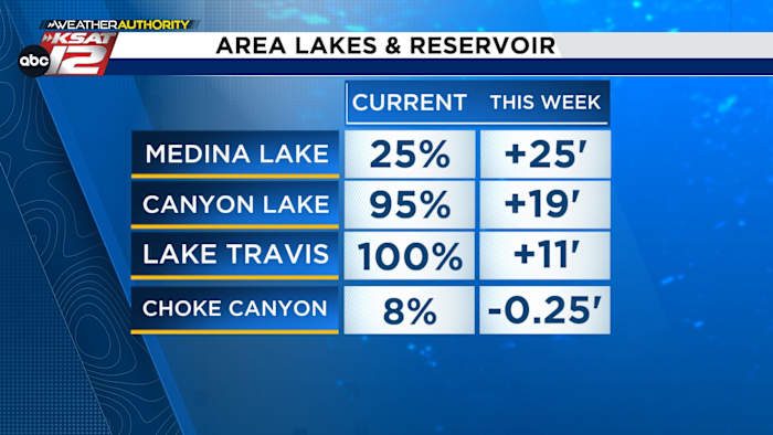
Areas that could continue to experience high water include those near rivers, creeks, and flood-prone areas. Residents should remain vigilant and avoid flooded roads. The Edwards Aquifer continues to recharge, while Medina Lake and Canyon Lake are expected to receive additional inflow from swollen rivers and tributaries over the coming days.
The heavy rain pattern is shifting northwest, giving way to a quieter forecast. Expect a mix of sun and clouds Saturday with mostly sunny skies Sunday. Highs will reach the mid-90s, with elevated humidity making it feel warmer.
Extended Forecast
Expect a hotter, drier pattern next week as high pressure builds. While no significant rain is forecast, lingering humidity will keep heat index values elevated. Prepare for a return to typical July heat.
Original reporting: San Antonio, TX News (HLL/CB) — read the source article.