An active weather pattern is lining up to affect San Antonio this week, with thick humidity and gusty winds holding temperatures up today and a more significant threat arriving Tuesday night. Meteorologists are watching a front and dryline that could kick off a line of storms pushing into the area around midnight, bringing the potential for severe weather, heavy downpours, and localized flooding. This piece walks through what to expect today, the Tuesday night threat, the uncertain midweek outlook and how to stay ready as holiday plans approach.
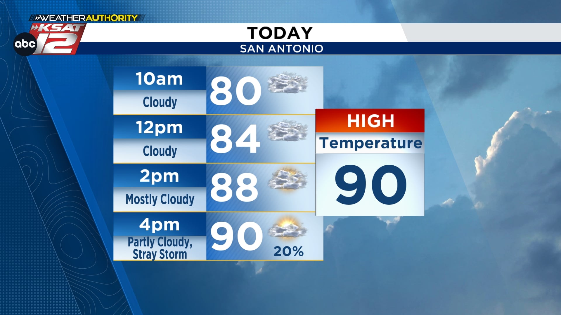
Today will feel warm and muggy across the region, with gusty winds keeping any real relief from developing overnight. A few breaks of sun this afternoon should help highs climb near 90 degrees, so expect that summer feel to return quickly. Rain chances are low overall, though a stray shower or brief storm can’t be ruled out as small-scale disturbances linger in the atmosphere.
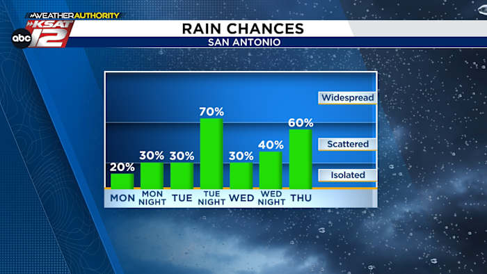
The setup flips Tuesday evening when a cooler front moving in from the northwest meets a dryline of hotter, drier air and the sticky Gulf flow over South Texas. That collision zone will be the catalyst for storms after sunset, and as energy organizes, those storms are expected to grow into a linear band that moves quickly to the south. Forecast trends point to that line reaching the San Antonio area near or just after midnight, so late-night travel could be impacted. While the line may be fast-moving, it still has the ingredients for some severe hits where dynamics and instability line up.
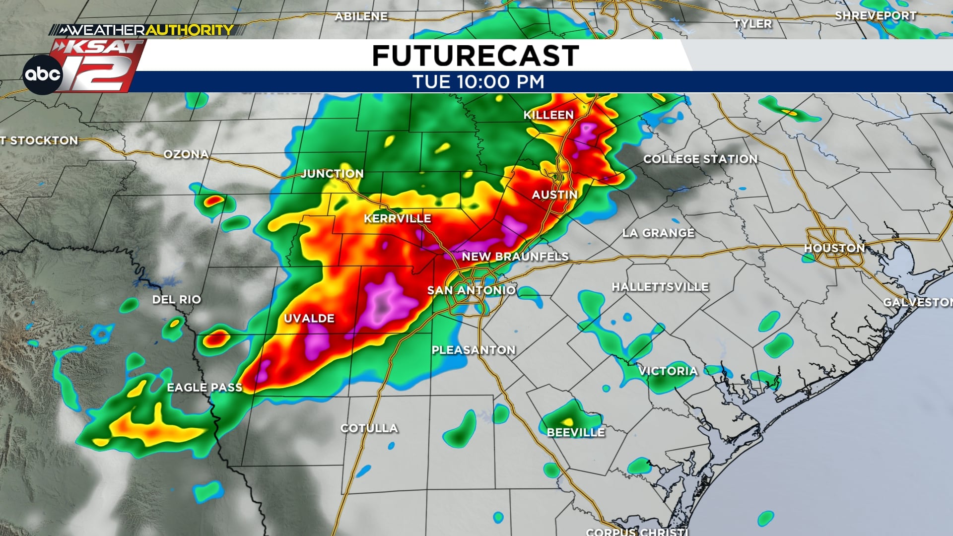
Storms will vary in intensity along that line, and two hazards stand out: damaging straight-line winds and brief pockets of very heavy rain. Wind gusts can down limbs and cause power outages, while intense downpours over a short time can overwhelm urban drainage and lead to street flooding. Even storms that move quickly can drop one- to two-inch bursts of rain that turn intersections into hazards, so driving late Tuesday night or early Wednesday morning isn’t recommended if a line is moving through. Local storm severity will hinge on small shifts in timing and track, so neighborhoods west or east of downtown may see very different conditions.
The pattern doesn’t shut off after that initial round; model guidance keeps the atmosphere active through midweek and into the holiday weekend, though exact timing of additional rounds remains uncertain. Each wave carries the risk of strong storms and periods of heavy rain, so multiple rounds could increase the chance of localized flooding over time. That uncertainty is especially relevant for Memorial Day plans, since a forecast that looks quiet today can shift toward wet later in the week as systems evolve. Forecasters will be watching trends closely and updating timelines as data sharpens up.

Practical steps now will make a big difference later: secure outdoor furniture, charge cell phones and keep a battery-powered radio or another way to receive warnings. If you have plans that involve travel or events outdoors, build flexible timing into those plans and know alternate routes that avoid low-lying roads. Never drive through floodwater; just six inches of moving water can sweep a person off their feet and a foot can float many vehicles. For property concerns, move valuables from basements or low storage to higher ground if you are in a spot prone to pooling water.
For those who work nights or commute late, check forecasts before heading out and consider delaying nonessential trips while the line moves through. If severe thunderstorm warnings are issued, move indoors away from windows and avoid using electronics that are plugged in during lightning activity. Remember that storm threats can evolve quickly; one city block can miss the worst of a storm while the next block gets hit hard, so local updates matter. Keep young children, pets, and elderly family members in mind when making safety decisions; rapid changes in the forecast can complicate plans for vulnerable people.
We will continue to watch model trends and fine-tune timing as we get closer to each event, passing along new information the moment confidence improves. Stay weather aware with multiple sources and make a simple plan for alerts so you don’t miss warnings that could save time or lives. Check back for updated timing and impacts as forecasters reconcile radar, satellite and high-resolution guidance in the hours ahead.
- WATCH LIVE: Doppler Radar
- Hourly and 10-Day Forecast
- Download FREE KSAT Weather Authority App: Up-to-date forecast information and livestreams from trusted local meteorologists.
- KSAT Connect: Share your weather photos.


