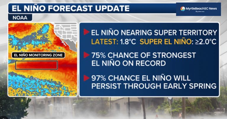
Forecasters are warning that a Super El Niño is forming, with the Climate Prediction Center assigning better than a 90 percent chance of a very strong event this fall and winter. For Horry County, where tourism, golf and ocean‑front real estate drive the economy, the weather pattern is more than a distant scientific curiosity.
What a Super El Niño Means for the County
El Niño’s warm Pacific waters shift atmospheric heat and bend jet streams, influencing storm tracks across the United States. A strong event typically produces a subtropical jet that increases wind shear over the Caribbean and Atlantic, which this year has already reduced the number of Atlantic hurricanes expected. NOAA’s August outlook projects a below‑normal 2026 hurricane season, with a 75 percent chance of below‑normal activity.
While fewer hurricanes sound like good news for beachgoers, the same jet stream that suppresses tropical storms this fall will later drive more frequent winter storm systems into the Southeast. Residents should expect a wetter winter, especially along the coastal plains.
Rainfall Outlook
National Weather Service meteorologist Courtney Maskell says El Niño winters usually bring above‑average precipitation to the Carolinas. Federal long‑range models show a 70‑80 percent chance of above‑normal rain across the Lowcountry and Coastal Plains during December‑February. Horry County sits at the wet end of that gradient, making a rainy season the most reliable forecast.
For farmers and row‑crop growers in western Horry, the extra moisture could break lingering drought conditions and replenish the shared aquifer. That is a clear benefit for the agricultural community.
Temperature Uncertainty
Temperature forecasts are less certain. The Farmers’ Almanac predicts a cool, wet, stormy Southeast, but its methodology is not peer‑reviewed. Federal outlooks suggest milder temperatures across Virginia, the Carolinas and Georgia, and Maskell notes there is no clear temperature split between El Niño and La Niña patterns. In short, expect rain; expect cold only as a coin flip.
Impact on the Golf Economy
Horry County’s golf industry thrives in the shoulder seasons—October‑November and February‑April—when the federal outlook flags the highest rainfall probabilities. Wet ground and frequent storm systems can turn fairways into cart‑paths, force course closures without makeup dates, and reduce green‑fee revenue. Package operators lose room nights, and local businesses that depend on golf tourism feel the pinch.
Conversely, the same rain that challenges golfers also helps keep the county’s water supply healthy, a vital consideration for the region’s long‑term growth.
Coastal Concerns
Strong El Niño winters tend to generate more nor’easters and Gulf‑coast storm systems. For the eight‑mile stretch of Myrtle Beach shoreline, the risk is not a single catastrophic surge but the cumulative effect of repeated moderate storms arriving on high tides. Erosion and nuisance flooding can strain the $9.7 million renourishment project the city and county funded together.
Local officials and residents should monitor coastal forecasts closely and be prepared for incremental damage rather than waiting for a headline‑making hurricane.
Bottom Line for Residents
Expect a wetter winter with the possibility of occasional snow in higher elevations, but do not count on a snow‑free season. The increased precipitation will aid agriculture and water resources while posing challenges for golf courses, coastal infrastructure and businesses that rely on dry conditions.
Staying informed about the evolving forecasts and planning for the wet conditions will help Horry County families, businesses and faith‑based community groups navigate the season with confidence.
Original reporting: MyrtleBeachSC News — read the source article.