Oklahoma will see rain and thunderstorms beginning early Thursday, bringing a noticeable cooldown across the state from Oklahoma City to the panhandle, and forecasters expect only a low risk of severe weather as the system moves in.
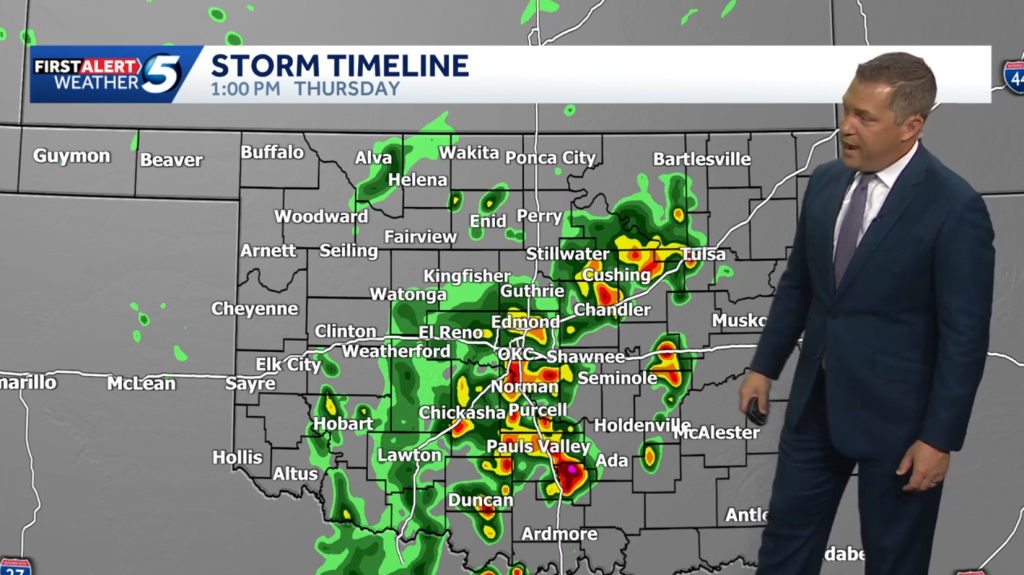
A broad storm system will sweep into Oklahoma Thursday morning, producing steady rain bands and pockets of heavier downpours. Showers will arrive first in western counties and spread east through the afternoon, so timing will vary depending on where you are. The setup favors multiple waves of precipitation rather than a single, intense burst.
Thunderstorms will accompany many of the heavier rain bands, but atmospheric conditions look relatively stable for organized severe storms. That low risk does not mean zero risk; hail or brief gusty wind could still happen in stronger cells. Most Oklahomans should expect nuisance impacts rather than widespread damage.
Rain totals will be uneven, with lighter amounts across the panhandle and northern plains and higher totals possible in central and southeastern counties. Some locations could pick up a half inch to an inch of rain, while localized pockets under slow-moving storms might see more. Flooding is unlikely for urban areas, but poor drainage spots and low-lying roads could become temporarily hazardous.
Temperatures will drop behind the front, bringing a crisp change from the recent mild stretch. Highs that might have reached the 70s during the week will retreat into the 50s and 60s Thursday and Friday. Cooler nights will follow, with lows dipping into the 40s in many places, so keep a light jacket handy.
Expect travel slowdowns during the morning and evening commutes as wet roads and reduced visibility become factors across metro areas like Oklahoma City and Tulsa. Drive slower than usual, use headlights in heavy rain, and give larger vehicles plenty of space. If you have outdoor plans, consider moving them inside or postponing until conditions clear.
Agriculture and outdoor work will get a mixed blessing from the rain, with beneficial moisture for pastures and summer crops but a few delays for fieldwork. Livestock should be sheltered if thunderstorms produce sharp wind gusts or brief heavy rain. Gardeners will welcome the refill for soil moisture, though muddy fields could slow planting or mowing.
Preparation is straightforward: stash a rain jacket or umbrella in your car, check tire tread and wiper blades, and keep a phone weather app set to alert for your county. Schools and event organizers should monitor updates in case localized flooding or gusty cells require adjustments. Remember that forecasts can change, so staying tuned to local bulletins is the best approach.
At the heart of this pattern is a frontal system pushing southeast, supported by a modest upper-level disturbance that sparks the showers and storms. The air mass ahead of the front will be mild and somewhat moist, but instability is limited, which is why severe threats are expected to remain low. Once the front clears, drier, cooler air will take over and weaken the precipitation chances.
By the weekend the state should see a decline in rain coverage and a return to sun for many areas, though mornings may stay brisk. Expect the atmosphere to stabilize, reducing thunderstorm potential and allowing outdoor activities to resume more comfortably. Keep an eye on short-term forecasts for exact timing in your county so you can plan errands and weekend plans accordingly.


