The setup over San Antonio and South Central Texas will feel like a weather tug of war this holiday weekend, with rain tapering here, heavier showers lingering to the west, and a threat of isolated storms returning later today and again tonight. Meteorologists are watching westward energy that could crank rain chances back up for Saturday, while Friday looks mostly quiet and Sunday promises a break with warmer sunshine. This article walks through what locals should expect from the rest of today into Memorial Day, highlighting flood concerns, timing uncertainties, and temperature trends for the holiday.
Rain is ending in San Antonio this morning, but the atmosphere remains busy just to the west where heavier cells are organizing. That means we get a breather now, but conditions are primed for isolated redevelopment as the day warms. Keep thinking about street flooding; urban areas that soaked up earlier downpours could see runoff issues if storms redevelop over the same neighborhoods.
The afternoon should give us a lull in activity, with pressure and drier pockets keeping most areas quiet through the early afternoon hours. That said, isolated showers and storms are expected to reappear late in the day as moisture and heating combine. Since these will be scattered, timing and exact placement will be a challenge, but the threat for brief heavy rain and brief gusty winds is real where storms fire.
Another round tonight is on the table, driven by disturbances moving in from the west and northwest. If that energy holds together, we could see clusters of storms push eastward after dark, prolonging flood risk for low-lying spots and poorly drained streets. Overnight storms carry the added concern of reduced visibility and slick roads, so plan for slower travel if you have late plans.
Friday opens with a chance for morning showers, then should trend toward a more settled afternoon for most of the San Antonio area. Skies will generally be partly cloudy and temperatures will be warm enough to feel like late spring. With less widespread forcing, any storms that pop will likely be isolated and short-lived.
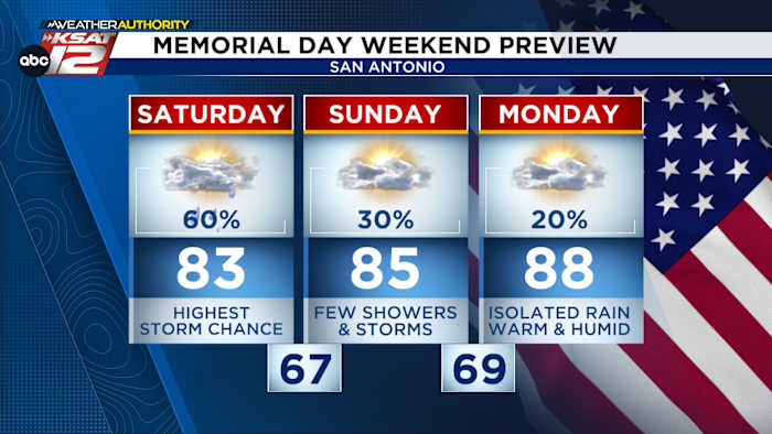
Saturday is the wildcard of the holiday weekend, with energy from the west raising rain chances significantly—models cluster around a 60 percent chance for showers and storms. The upper-level pattern looks messy, so timing and intensity will be hard to nail down until closer to the event. Expect clouds and periods of rain to keep temperatures a bit cooler, and the potential for localized heavy totals where cells train or stall.
Sunday looks friendlier for outdoor plans, with drier air working back in and the sun returning across much of the region. Highs should push into the mid-80s, making it a comfortable day for Memorial Day prep or last-minute errands. Still, isolated showers can’t be ruled out in the afternoon, but coverage should be much lower than Saturday.
Memorial Day itself will be mostly warm with only isolated storm coverage expected, near 20 percent in most forecasts. Temperatures should climb close to 90 degrees, which will feel warm but not oppressive if humidity holds modest. That low storm chance makes it a decent option for outdoor gatherings, though bring a light plan B in case a stray shower sneaks in.
Street flooding has been the consistent headline during these rounds of rain, and it deserves attention again today. Short bursts of intense rainfall over paved or saturated ground can create dangerous runoff in minutes, especially in low spots and underpasses. Avoid driving through standing water and be mindful of neighborhood drains that can back up quickly after a repeat downpour.
Timing remains the biggest forecast headache, especially with Saturday’s system, where model guidance diverges on when heavier action arrives. That uncertainty means anyone planning activities should watch updates and be ready to shift plans on short notice. Local forecasts and radar will be the best tools to track the oncoming clusters as they get closer to San Antonio.
For those with outdoor Memorial Day plans, think layered scheduling: a morning or early afternoon barbecue looks most reliable for now, while late afternoon and evening carry higher chances for isolated showers or storms. If you’re headed west out of town, be aware that the deepest moisture and heaviest rain will be organizing there first. Pack an umbrella and consider covered or alternative venues if you have critical events scheduled for the evening.
Temperatures across the weekend will trend from warm to slightly cooler when clouds and rain are most persistent, then back toward the upper 80s and low 90s by Monday. The coolest readings will show up under widespread cloud cover and steady rain on Saturday, with recovery to sunnier, warmer conditions by Sunday and Monday. Monitor heat and humidity if you have extended outdoor exposure on the holiday.
Localized impacts matter more than broad averages when storms are scattered, so neighbors just a few miles apart can experience very different conditions. One block might be soggy and windy while another stays dry and breezy, which is frustrating but typical in these setups. Keep an eye on live radar and local advisories to know what your street will see.
For boating and river recreation, sudden storms can create hazardous waves and quick changes in wind direction, so check conditions frequently and stay closer to shore when a storm threat exists. Lightning is always a risk with any thunderstorm, so the rule of returning to land at the first sign of lightning or thunder remains critical. Safety-first decisions will preserve long weekend plans better than risky last-minute choices.
Storms that do organize could produce brief gusty winds, small hail, and downpours that reduce visibility rapidly along roadways entering or leaving San Antonio. These conditions are short-lived but intense enough to cause tree damage or roadside debris in a few spots. Keep phones charged and alerts enabled; sudden warnings could be issued if cells intensify.
With the pattern staying active through at least Saturday, the rain totals will be highly dependent on storm training and slow-moving clusters. Some neighborhoods could accumulate respectable totals while nearby areas remain largely dry. That variability is why flood statements and localized alerts are more useful than blanket forecasts in these situations.
Keep a basic weather kit handy: phone alerts, a battery pack, and a flashlight if heavy storms push through at night. Being prepared for short-term outages or quick-plan changes will make the holiday smoother for everyone. Local weather teams will update guidance as the systems evolve, so tune in before travel or large gatherings.
Overall, San Antonio residents should expect a weekend of mixed signals—windows of sun mixed with rounds of rain and isolated storms, with Saturday presenting the biggest uncertainty for heavy, widespread rain. Use the quieter windows for key outdoor activities and remain flexible for late-day shifts that bring showers or storms back to the forecast area. Staying informed will be the easiest way to enjoy the holiday while avoiding the worst of the wet weather.


