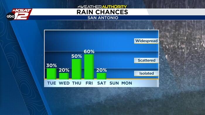
San Antonio residents can expect a more active weather pattern this week, with a steady veil of clouds and multiple opportunities for rain. While early showers will be isolated, the most significant rainfall chances arrive later in the week.
Early week: Isolated showers
Tonight through Tuesday, spotty showers are possible across the area, but coverage will be limited to about 30% of the region. These showers are expected to be brief and scattered, so most of the city will remain dry.
Mid‑week: Light chances
Wednesday may bring another round of stray showers, though the probability remains low. Temperatures will stay in the comfortable 70s, and the overall impact on daily activities should be minimal.
Thursday and Friday: Best odds for rain
A new disturbance will combine with lingering moisture from Pacific Tropical Storm Vance as it moves inland Thursday into Friday. The greatest chance for more significant rainfall will be west of I‑35, but San Antonio’s rain probability does increase later Thursday and into Friday. Residents should anticipate a mix of clouds and rain that will help keep temperatures down.
Halloween outlook
For those planning Halloween festivities, the forecast shows only a modest 20% chance of rain. Conditions are expected to be comfortable, with daytime highs remaining in the 70s, making it a pleasant evening for trick‑or‑treating.
What to expect
- Isolated showers tonight through Tuesday (≈30% coverage)
- Scattered showers possible Wednesday
- Increased rain chances Thursday‑Friday, especially west of I‑35
- Temperatures steady in the 70s throughout the week
- Halloween night: low rain risk, comfortable weather
Residents should stay tuned to local updates for any changes in timing or intensity, especially if outdoor plans are in place. Carrying a light rain jacket on Thursday and Friday is advisable, while the early part of the week should remain largely dry.
Original reporting: San Antonio, TX News (HLL/CB) — read the source article.