Residents of the Jersey Shore, Long Island and the broader Tri‑State area should begin preparing for a potentially wet and windy weekend, as meteorologists track a developing low‑pressure system that could become a nor’easter.
Storm development and timing
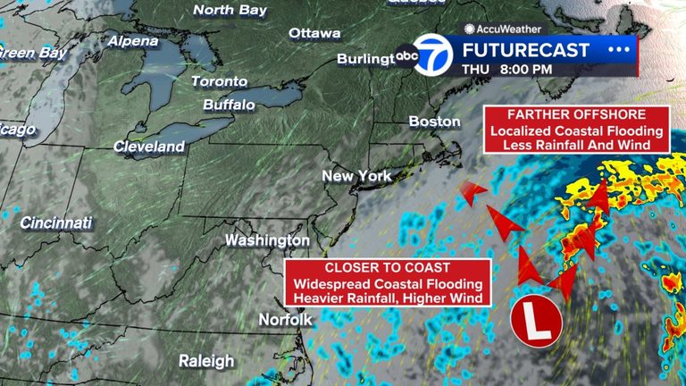
The system is expected to form off the Carolina coast on Wednesday. If it moves closer to the shoreline and intensifies, the risk of damaging winds, storm surge and beach erosion rises sharply. The National Weather Service has issued coastal flood watches from Wednesday afternoon through Thursday evening, and a gale watch for all coastal waters through Thursday.
Possible impacts
Forecasters warn of a range of hazards, including rough surf, high rip‑current risk, coastal flooding, beach erosion, strong gusty winds and heavy rainfall. Pockets of drenching rain could exacerbate existing coastal flooding, especially in low‑lying neighborhoods and areas prone to runoff.
Should the low pressure be captured by an upper‑level trough and be drawn westward toward the coast, the strongest impacts will be felt along the shoreline. If the system remains farther offshore, inland areas may see only moderate rain and wind, while coastal communities continue to face the greatest threats.
What residents can do
Local officials advise residents to secure outdoor items, avoid unnecessary travel near the water, and stay informed through official channels such as the National Weather Service, local emergency management offices and trusted weather apps. Those living in flood‑prone zones should consider moving valuables to higher ground and reviewing evacuation routes.
Schools and businesses are monitoring the situation closely. Parents should check with their children’s schools for any potential closures or delays, and commuters should allow extra time for travel, especially on routes that run near the coast.
Looking ahead
Friday through Sunday will largely depend on the storm’s track. A closer approach could bring a wet and windy weekend even to inland areas, while a more distant path would limit the most severe effects to the immediate coastline.
Bottom line: expect cloudy skies, gusty winds and the possibility of heavy rain this weekend, with the greatest impacts along the shorelines of New Jersey and Long Island. Stay tuned to local updates and heed any advisories issued by emergency officials.
Original reporting: Brookhaven News – ABC7 New York — read the source article.