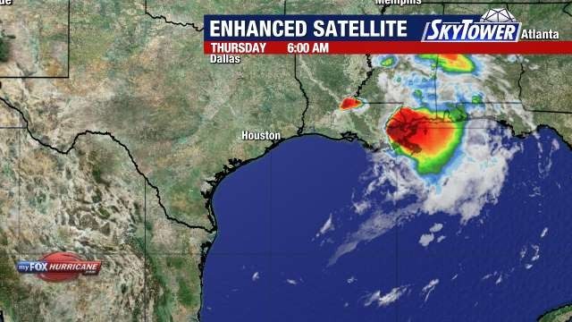
Post-Tropical Cyclone Arthur has weakened after making landfall along the upper Texas coast, but its remnants continue to pose a significant flooding threat across portions of the southeastern United States.
Local Impact
Although Arthur is no longer a tropical storm, the system continues to bring widespread heavy rainfall. The National Hurricane Center forecasts rainfall totals of 5 to 10 inches, with isolated amounts approaching 20 inches, from the Texas coast eastward into portions of Louisiana, Mississippi, Alabama, western Georgia and the Florida Panhandle through early Friday.
Forecasters warn the heavy rainfall could trigger dangerous and potentially life-threatening flash flooding across parts of the region. Scattered thunderstorms remain concentrated east of the storm’s center, while seas near the Gulf Coast remain elevated at around 11 feet.
High Rip Current Risk for Florida Gulf Beaches
The National Weather Service in Ruskin has issued a high rip current risk from 8 a.m. Thursday through Friday morning for several counties along Florida’s Gulf Coast, including Pinellas, Hillsborough, Manatee, Sarasota, Charlotte, and Lee counties.
Beachgoers are advised to exercise caution when swimming in the Gulf, as dangerous rip currents can quickly pull even experienced swimmers away from shore and into deeper water. Officials recommend swimming near a lifeguard whenever possible and following proper safety procedures if caught in a rip current.
Original reporting: Tampa Bay Florida News (HLL/CB) — read the source article.


