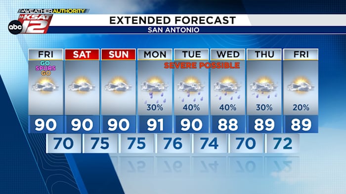
I’ll walk you through today into the weekend and the risk of storms next week around San Antonio, with notes on West Texas hotspots like Del Rio and Eagle Pass and what to watch along the Rio Grande. Expect a string of warm, humid afternoons near 90 degrees, some morning clouds and an uptick in storm chances by Monday that could linger toward Memorial Day weekend.
Today starts with a short-lived blanket of morning clouds before we break into partly cloudy skies in the afternoon. Temperatures will flirt with the upper 80s to near 90, and humidity makes the heat feel stronger than the thermometer says. Heat index values return to the forecast, so plan outdoor plans with some caution and water on hand.
A weak disturbance will be the wildcard this afternoon, stirring storms across parts of West Texas. That activity could target areas like Del Rio and Eagle Pass this evening, tracking along or near the Rio Grande. The good news for San Antonio is that most of this should stay to the west of the city, though it’s worth keeping an eye on radar late in the day.
Weekend weather shifts a bit toward clouds at the start of both Saturday and Sunday mornings, with drizzle or a few sprinkles possible Sunday morning for some spots. Afternoons should still warm up and become humid, so it will feel like classic late-spring weather. If you have outdoor plans, aim for early or late in the day to dodge the heat and any brief downpours.
By Monday the pattern turns more active and unpredictable. Isolated storms are likely Monday evening, and while we can’t pinpoint where each cell will pop, any storm that forms has the potential to become strong or severe. That makes monitoring updates on Monday important, especially if you live in spots that tend to see sudden heavy downpours.
On Tuesday a weak front nudging into North Texas raises the overall rain chances and complicates the forecast further into the week. Timing and placement remain uncertain, but enough instability exists that officials and meteorologists will be watching for severe weather possibilities. Rain chances may hang around through the week and could extend into Memorial Day weekend for parts of the region.

For quick access to tools and updates, check these local resources maintained by trusted meteorologists and stations. Live radar, hourly and 10-day outlooks, a free weather app, and community photo sharing make it easy to stay informed. Keep your phone weather alerts on so you hear warnings as soon as they are issued.
- WATCH LIVE: Doppler Radar
- Hourly and 10-Day Forecast
- Download FREE KSAT Weather Authority App: Up-to-date forecast information and livestreams from trusted local meteorologists.
- KSAT Connect: Share your weather photos.

Keep a simple plan: water, shade, and a way to get alerts if storms spin up fast. For anyone traveling through Del Rio, Eagle Pass, or along the Rio Grande this evening, give yourself extra time and watch conditions closely. If severe-weather products are issued next week, take them seriously and move to safety when instructed.


