Today’s weather across Iowa is dominated by a cool, overcast front that moved through the state yesterday. The front has ushered in drier air, but lingering moisture means light rain and drizzle will persist throughout much of the day.
Sunday outlook
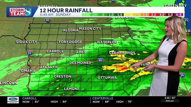
Most of southern and eastern Iowa received about an inch of rain overnight, while parts of southeast Iowa saw between two and three inches. Storms are now moving out of eastern Iowa, and the chance of additional storms remains low for the rest of the day.
High temperatures will top out in the mid‑60s, with a gentle northeast wind at 10‑20 mph. Expect cloudy skies and scattered rain showers, with the possibility of light drizzle lingering into the evening.
Tonight and Monday
Tonight, clouds will dominate the sky and scattered light rain may continue. Low temperatures are expected near 57 °F, with winds easing to 5‑10 mph from the northeast.
Monday will see similar conditions: scattered light rain, cloudy skies, and a high near 60 °F. Winds will remain from the northeast at 10‑15 mph.
Tuesday through Friday
By Tuesday, high pressure will settle over the state, bringing clearer and sunnier skies. Temperatures will feel fall‑like, staying in the low to mid‑60s for the rest of the week.
Rain chances will stay low for most of the week, with only a small chance of showers on Thursday and Friday. Residents can look forward to a drier, more settled pattern as the week progresses.
How to stay informed
For real‑time updates, Iowa residents can check KCCI’s skycam page, which offers aerial views from more than 25 locations across the state. The interactive radar and weather alerts on the KCCI website provide additional detail for anyone planning travel or outdoor activities.
Overall, the cooler air and reduced storm activity should make for a comfortable start to the week, with the promise of clearer skies and typical autumn temperatures ahead.
Original reporting: KCCI Des Moines — read the source article.