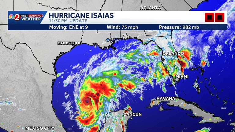
The National Hurricane Center (NHC) announced Wednesday night that Hurricane Isaias has reached Category 1 status with maximum sustained winds of 75 mph and a central pressure of 982 mb. At 11 p.m. EDT the storm was located about 180 miles northwest of Progreso, Mexico, and roughly 460 miles south‑southwest of the Mississippi River’s mouth.
Current watches and warnings
The NHC issued a series of watches and warnings for the northern Gulf Coast:
- Storm Surge Watch: from the mouth of the Mississippi River to the Steinhatchee River, FL
- Hurricane Warning: Ocean Springs, MS to the Bay/Gulf County Line, FL
- Tropical Storm Warning: Jefferson/Plaquemines Parish Line, LA to west of Ocean Springs, MS; and from the Bay/Gulf County Line east to the Aucilla River, FL
- Additional Storm Surge Watch: Steinhatchee River to Yankeetown, FL
First Warning Meteorologist Cam Tran noted that Central Florida is not expected to see direct impacts, though the storm will pull abundant moisture into the region, keeping rain chances high.
Hazards expected
Storm surge: The combination of surge and high tide could produce flooding of 5‑7 feet in areas from Ocean Springs, MS to Indian Pass, FL, with lower but still dangerous surges along the Mississippi River mouth, Mobile Bay and the Florida coast.
Wind: Hurricane‑force winds are forecast within the warning area Friday night into early Saturday, with tropical‑storm conditions beginning Friday. Gusts may also affect parts of the Yucatan Peninsula on Thursday.
Rainfall: Isaias is expected to deliver 1‑3 inches of rain Thursday across the eastern Bay of Campeche, with isolated higher amounts. From Friday through the weekend, the system could produce 3‑7 inches of rain along the central Gulf Coast—from southeastern Louisiana to the Florida Panhandle—and 1‑3 inches across much of the Southeast, with isolated totals up to 10 inches. Flash, urban and river flooding are possible.
Tornadoes: Isolated tornadoes may develop Friday night in coastal Alabama and the Florida Panhandle, with the threat persisting into Saturday for eastern Alabama, western Georgia and the Panhandle.
Surf: Swells will begin Thursday on the western and northern Yucatan Peninsula and spread northward, creating life‑threatening surf and rip currents along the Gulf Coast.
What residents should do
Authorities urge anyone in the warned areas to review evacuation routes, secure property, and stay tuned to local weather updates. The NHC expects Isaias to turn northeast Thursday and continue that motion Friday, positioning the storm for a likely landfall along the northern Gulf Coast late Friday or early Saturday.
For the most current forecasts, residents should follow the First Warning Weather team on WESH 2, download the WESH 2 News app, and heed any local emergency management directives.
Original reporting: WESH Orlando — read the source article.