Storms swept through San Antonio overnight and left heavy rain across the metro and nearby landscapes, including the Rio Grande corridor and the Edwards Plateau, and more rounds are expected through Thursday and into the Memorial Day weekend. This piece lays out timing, what to watch for on roads and low spots, and how the pattern could affect Spurs watch parties and holiday travel around Bexar County and the surrounding hill country.
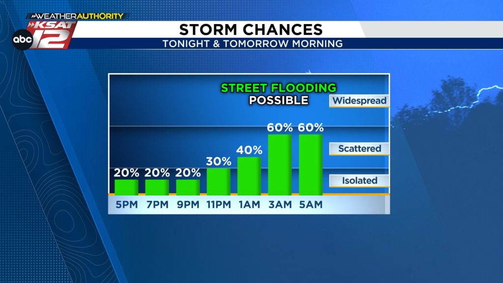
Late-night downpours already dropped between about three quarters of an inch to two inches in pockets around the city, so many streets and low-lying yards are carrying more water than usual. That saturation means even short, intense storms can produce street flooding and surging creeks. With the ground soaking wet, the region is primed for flash issues if new cells redevelop quickly.
Thursday morning should feel a bit calmer overall, but there is still roughly a 20 percent chance for stray storms into the evening. If you’re heading out to Spurs watch parties or planning short trips, think about parking on higher ground and keeping an eye on route conditions. The higher-end threat for stronger, faster-moving storms is tucked west of the city along the Rio Grande and over the Edwards Plateau, where a bit more instability can fuel heavier bursts.
Storms building to our west overnight can race through the metro and dump heavy rain in a short period of time, which is the main flashpoint for street and low-water crossing flooding. With many roads already damp or saturated, even 30 to 60 minutes of intense rain can create hazardous conditions for drivers. Right now the setup favors heavy rain over widespread hail or damaging winds, though isolated gusts remain possible and can cause sudden visibility and debris issues on roadways.
The timing of overnight activity often shifts by a few hours depending on storm evolution, so check forecasts before your morning commute and leave a little earlier if roads look slick. Thunder and bursts of rain can wake kids, pets, and people heading out early, so consider moving vehicles off low driveways and away from known flood-prone spots. It also makes sense to clear yard and driveway drainage paths where possible to limit pooling around entrances.
Friday appears to be the quietest day in the short term, offering a cleaner window for outdoor errands or small plans. The pattern swings back Saturday with another round of showers and storms possible, and because area soils and roadways will already be saturated, any heavy cell could prompt rapid rises in creeks and localized street flooding. Cooler conditions are likely when clouds and rain stick around, so outdoor plans might feel damp and a touch chilly compared with recent warm snaps.
Sunday and Memorial Day currently look like the best chances for dry weather and some sun, but isolated showers cannot be ruled out, especially in the hill country and west-facing neighborhoods. If you have daytime gatherings plan for the drier windows and have a quick backup location indoors just in case a band of storms sneaks through. Keep checking up-to-the-minute updates because the odds of widespread rainfall are forecast to drop by Sunday, improving outdoor prospects compared with midweek.
Looking beyond the long weekend, the overall weather pattern stays active with fronts and disturbances likely to wander back into the region early next week. That means wet days could return and your rain plan should stay handy for the start of next week. For drivers and party hosts alike, the simple rules still apply: respect flood-prone spots, avoid driving through standing water, and keep kids and pets away from fast-moving creeks and drainage channels after heavy rain.
Quick weather resources
- WATCH LIVE: Doppler Radar
- Hourly and 10-Day Forecast
- Download FREE Weather Authority App: Up-to-date forecast information and livestreams from trusted local meteorologists.
- Share weather photos and tips


