Residents of Florida can look forward to drier conditions later this week as a developing East Coast Nor’easter is set to funnel dry air southward. While Tropical Storm Fay continues to weaken far out in the Atlantic, the National Weather Service and local meteorologists are monitoring three separate systems that could affect the state.
Fay’s Weakening Trend
As of Tuesday morning, Tropical Storm Fay’s maximum sustained winds have dropped to about 40 mph, well below the threshold for a hurricane. The storm remains thousands of miles from the U.S. coastline and is considered a non‑factor for Florida’s weather. Forecast models show Fay lingering for a couple more days before dissipating entirely.
Nor’easter Development and Its Impact on Florida
Simultaneously, a low‑pressure system is forming off the U.S. East Coast. Meteorologists expect this Nor’easter to bring significant rain and wind to New England and the broader Northeast. More importantly for Floridians, the atmospheric setup associated with the Nor’easter will act as a conduit, pulling much drier air from the north and pushing it down the Atlantic seaboard toward the Sunshine State.
The dry air surge is expected to arrive later this week, reducing humidity levels and limiting the chance of additional rain showers in central and southern Florida. Coastal areas may still see isolated showers, but overall precipitation chances are expected to decline.
Potential Development off Africa
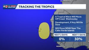
In addition to the Nor’easter, forecasters are watching a disturbed weather area moving off the African coast. The system carries a 30 percent chance of developing into a tropical cyclone. Even if it strengthens, current model tracks suggest it will move northward toward the Cape Verde islands, posing no immediate threat to Florida.
Hurricane Polo in the Eastern Pacific
While the Atlantic basin is quieting, the Eastern Pacific remains active. Hurricane Polo, currently the strongest storm on the planet, has undergone rapid intensification and may approach near‑category‑5 strength with winds possibly reaching 175 mph. Polo is projected to move northwestward away from the U.S. coast, posing no direct risk to Florida.
What Floridians Should Expect
In summary, Florida can anticipate a period of drier, more stable weather as the Nor’easter’s influence pushes dry air southward. Residents should still stay informed of any updates from the National Weather Service, especially if local conditions change unexpectedly. The weakening of Tropical Storm Fay and the distant trajectory of Hurricane Polo both suggest a relatively calm outlook for the state in the coming days.
For the most current forecasts, consult local weather stations, the National Weather Service website, or trusted news outlets covering regional weather updates.
Original reporting: Tampa Bay Florida News (HLL/CB) — read the source article.