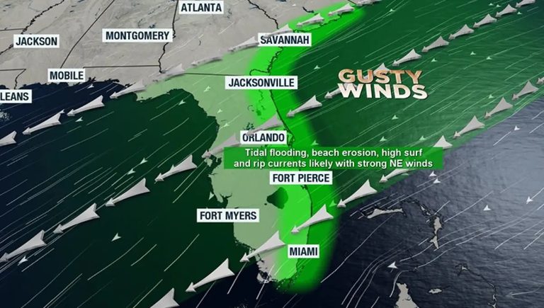
The National Weather Service has issued a series of warnings for Florida’s East Coast, noting that hazardous surf, dangerous rip currents, beach erosion and coastal flooding are likely to continue through the week. Residents from Jacksonville down to Miami are being urged to take precautions as the region battles a second nor’easter in just two weeks.
What’s causing the storm?
A ridge of high pressure over the eastern United States is funneling steady northeast winds toward the Atlantic, while a developing low‑pressure system over the southwestern Atlantic adds moisture and lift. The combination creates the classic nor’easter pattern that is now producing rough surf and persistent on‑shore flow.
Wind and wave conditions
Wind gusts of 35 to 45 mph are expected east of Interstate 95, with inland areas seeing a gradual decrease in wind speed as the system moves offshore. Gale‑force conditions are likely over the water, prompting small‑craft boaters to remain in port. Waves as high as 11 feet are forecast along the shoreline, and rip currents are expected to be especially strong, posing a serious risk even to experienced swimmers.
Coastal flooding and King Tides
The storm coincides with a period of elevated astronomical tides, commonly called King Tides. Low‑lying areas such as parking lots, docks and waterfront roads are already experiencing minor flooding. Drivers who encounter tidal water should rinse their vehicles thoroughly, as saltwater can accelerate corrosion and damage electrical components.
Additional King Tide episodes are projected for November 6‑9 and November 23‑26. If heavy rain accompanies those high tides, coastal flooding could become more severe, especially in neighborhoods that sit just above sea level.
Safety recommendations
Beachgoers should avoid entering the water when rip currents are posted and heed any lifeguard warnings. Those planning outdoor Halloween decorations should secure items or wait until the gusty winds subside. Small‑craft operators are advised to keep vessels docked until conditions improve.
Looking ahead
Forecast models suggest the northeasterly flow will linger for several more days before a pattern shift arrives over the weekend. Temperatures are expected to rise above seasonal norms, and scattered showers and thunderstorms may develop as the wind direction changes.
Residents are encouraged to stay informed through local weather updates and to follow any evacuation or road‑closure notices issued by county emergency management offices.
Original reporting: Jacksonville Today — read the source article.