DALLAS — Heavy rain arrives Thursday and could stick around through Memorial Day weekend, bringing scattered showers, pockets of heavier downpours and the usual headaches for anyone with outdoor plans. Meteorologist Berkeley Taylor and local crews are tracking multiple rounds of rain moving in from the west, with the highest coverage expected across western counties near I-35. This setup will make Thursday the coolest day of the week before temperatures bounce back into the mid 80s on Friday.
Rain moves in early Thursday from the west, but the first wave will be spotty as it approaches the metro. Expect scattered showers through the morning and into the afternoon, then a noticeable uptick in coverage later in the day. Areas that saw heavy rain earlier in the week will be watching closely because saturated ground can turn a downpour into localized flooding fast.
Severe storms are not the headline, but that does not mean things will be harmless. A few cells could briefly become strong, producing isolated flooding, hail and damaging winds that catch people off guard. That kind of quick-hitting, localized severe weather is hard to forecast down to the neighborhood level, so it pays to have a plan for sudden changes in conditions.
The primary short-term risk is flash flooding, especially where drainage is poor or previous rainfall has already soaked the ground. City streets, low-lying intersections and small creeks can run high with very little warning when heavy rain falls over a short period. Drivers should avoid flooded roads and never attempt to cross water of unknown depth, because those decisions are dangerous and often irreversible.
Temperature-wise, Thursday will be the coolest day of the week with highs peaking just under 80 degrees, offering a brief break from the usual late May heat. By Friday, the mercury climbs back into the mid 80s and that warmth will stick around into next week. Higher humidity combined with scattered rain chances will make the air feel sticky, so the heat will still be noticeable even when the sky is overcast.
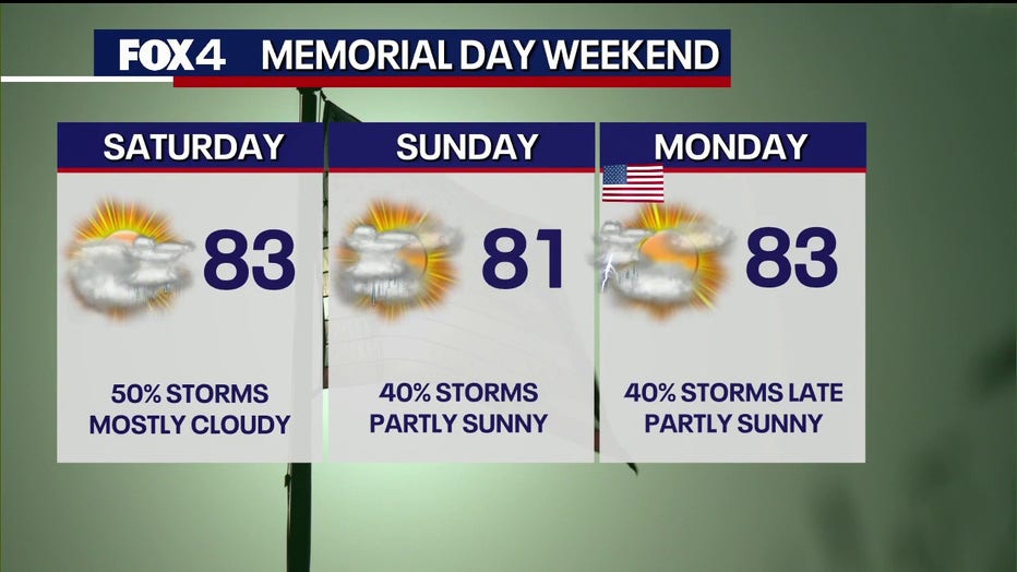
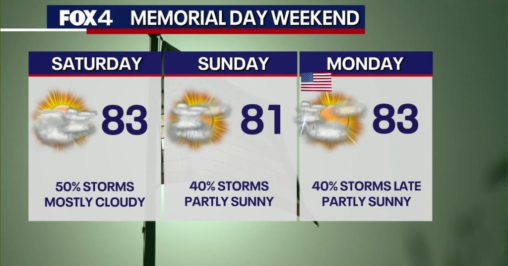
The holiday weekend will look unsettled, with at least a chance of rain each day through the seven-day outlook. Friday appears to have the lowest overall coverage of showers, but that does not guarantee dry weather for backyard barbecues or lake plans. Keep a backup plan for outdoor events, because scattered afternoon and evening showers can disrupt things at the last minute.
Forecast confidence in timing and areal coverage is good for the broad picture but weaker on the exact placement of heavier downpours. That’s the typical spring and early summer challenge when Gulf moisture and passing disturbances team up to spark multiple rounds of showers. Localized details matter a lot, so staying tuned to updates from forecasters will be the best way to avoid surprises.
Meteorologist Berkeley Taylor will have ongoing updates as conditions evolve, and local weather teams will monitor radar as showers push through the metroplex. If you plan to be outdoors, especially on holiday weekend days, check radar and short-term forecasts before heading out and during the activity. Small changes in timing can mean the difference between a pleasant afternoon and a soggy one.
For now, prepare for on-and-off rain through Thursday and scattered showers into Memorial Day and beyond, with isolated stronger storms possible. Protect outdoor gear, have flexible scheduling for events, and keep an eye on localized flooding potential if your area saw heavy rain recently. Simple precautions can keep plans salvageable and people safe when the weather decides to be unpredictable.