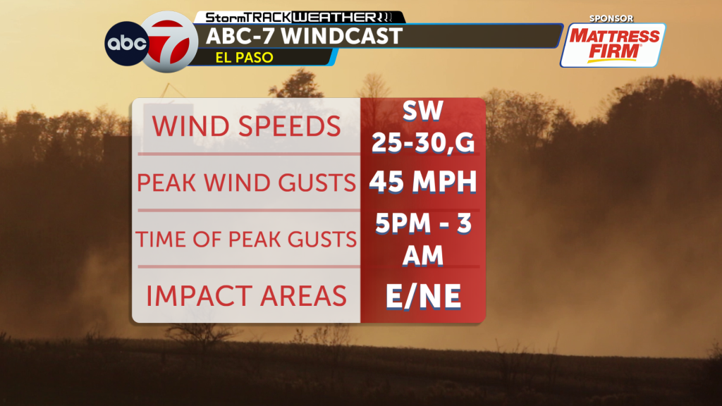
EL PASO, Texas — A strong push of dry, gusty air will hang over the Borderland into Monday, and the National Weather Service says conditions are ripe for critical fire weather. KVIA meteorologists warn southwest winds of 20 to 30 mph with gusts up to 45 mph will persist Sunday and Monday, and blowing dust may reduce visibility in spots. This piece walks through what to expect, what’s at risk, and practical steps residents can take now.
Winds this strong will whip low humidity into already parched brush and grass, creating a very volatile mix for any spark. The National Weather Service emphasizes that rapid fire growth is possible if a blaze begins, because gusts feed flames and spread embers long distances. With live fuels still dry across the Borderland, small fires can jump containment lines quickly.
Blowing dust is another part of the hazard picture and it can arrive suddenly, knocking down visibility on highways and surface streets. Drivers should be ready to slow down and use headlights if dust reduces sight lines, and larger vehicles can be especially vulnerable to crosswinds. If you encounter a dust cloud, pulling off the road and turning off lights until visibility improves is safer than trying to drive through it.
Outdoor burning, including yard debris and agricultural burns, becomes particularly dangerous under these weather conditions and should be postponed. Local fire departments and authorities often issue burn bans during critical fire weather, and those restrictions are not optional; they’re aimed at preventing disasters. Securing loose yard items and patio furniture will also reduce the chance of wind-driven debris causing property damage or igniting fires.
Residents who live in wildfire-prone areas should review basic preparedness steps now, like creating a 100-foot defensible space, keeping gutters clear, and moving combustibles away from structures. Make sure evacuation routes are known and that vehicles have fuel in case a quick departure is needed. Pets and livestock should have an evacuation plan and carriers or trailers ready to go.
Power disruptions are possible when high winds and falling trees interact with infrastructure, so a short-term outage kit is a smart move. Include water, flashlights, batteries, a charged phone, and any needed medications for at least 72 hours. If you rely on medical equipment that needs power, consider a backup generator or alternative arrangements before conditions worsen.
Keep an eye on official channels for updates; the National Weather Service will post changes to wind speeds, fire danger, and any Red Flag Warnings or advisories. Local broadcasters like KVIA will carry situational updates, school and road closures, and information from emergency managers. Social media can be useful, but confirm alerts through trusted local or federal sources before acting.
If you spot smoke or an active fire, report it immediately to local authorities rather than assuming someone else has called. Provide clear location details and describe what you see, including fire size and any structures threatened. Quick reporting improves response time and can make the difference between a small, contained incident and a rapidly spreading emergency.
Community coordination matters during episodes of critical fire weather, so check on neighbors who may be vulnerable, including the elderly and people with mobility limits. Volunteer organizations and local community groups often mobilize to assist with evacuations, sheltering, and pet care when fires threaten populated areas. Simple neighborly actions now can save lives and property later.
Expect the windy, dry pattern to last through Monday, and plan your activities accordingly to reduce ignition sources and exposure to dust. Follow the guidance from the National Weather Service and local officials, postpone risky outdoor work, and keep emergency plans and supplies accessible. Staying informed and prepared is the best way to minimize risk during this unsettled stretch of weather.


