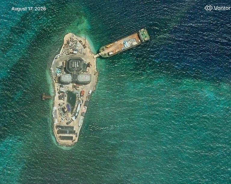
New construction on Yagong Island, a small islet in the Paracels archipelago, was identified in satellite imagery released on August 17. Analysts believe the three‑pronged structures could be the first phase of an early‑warning radar facility that would complement China’s larger base on nearby Antelope Reef.
Satellite evidence and timeline
The commercial imaging firm Vantor captured the latest picture on August 17 and noted that building activity on Yagong began in March and April of this year. The images show several concrete structures that resemble other radar and observation posts the Chinese military has erected elsewhere in the South China Sea.
Potential purpose
While the exact function of the Yagong installations remains unconfirmed, security analysts say the layout is consistent with early‑warning radar sites. Open‑source intelligence tracker Damien Symon described the possibility of a radar facility but cautioned that a definitive assessment is premature. Singapore‑based security scholar Collin Koh suggested the site is most likely a standalone observation post, possibly a radar station, given its limited scale.
Context of the Antelope Reef development
China completed the first phase of construction on Antelope Reef earlier this month, creating an artificial island nearly six kilometres long with a straight coastline that could accommodate a runway. The development has been framed by Chinese state media as serving civilian needs such as weather forecasting, fisheries protection, and scientific research, though the United States and its allies view it as a strategic military expansion.
The Paracels have been under Chinese control since 1974, when China seized them from the former South Vietnamese navy. Vietnam claims the entire group and has been expanding its own presence in the Spratly Islands further south. The Spratlys and surrounding waters are also claimed, in whole or in part, by the Philippines, Malaysia, Taiwan, and Brunei.
Strategic implications
Regional security analysts argue that the new Yagong structures, if indeed a radar site, would strengthen China’s surveillance and defensive posture over the northern portion of the vital trade waterway. The South China Sea remains a flashpoint between China and the United States, with the potential to affect any future conflict involving Taiwan.
The Chinese defence ministry did not respond to requests for comment. State media continue to emphasize the civilian aspects of the Antelope Reef project, while independent observers highlight the growing militarisation of the region.
International response
U.S. officials have repeatedly warned that China’s construction activities threaten freedom of navigation and regional stability. Allies in the area, including Japan and Australia, have called for adherence to international law and for all parties to avoid actions that could escalate tensions.
As satellite monitoring continues, further developments on Yagong Island and surrounding features will be closely watched for signs of additional military capability.
Original reporting: Appleton, WI News Feed (HLL/CB) — read the source article.