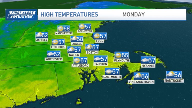
Residents of Boston and greater New England can look forward to a relatively quiet start to the workweek. Temperatures will hover in the mid‑to‑upper 50s, with persistent cloud cover and only a slight chance of scattered showers today. The weak weather system moving through the area is not expected to produce significant rain, though a few puddles may form in low‑lying spots.
Mid‑week outlook
Tonight, clouds will remain largely intact, keeping the night cool and overcast. Tomorrow’s forecast is drier, but the sky will stay mostly cloudy, offering little relief from the gloom. Wednesday looks to be the sunniest day of the week, though highs will still be confined to the mid‑to‑upper 50s, providing a modest break before the next system arrives.
Nor’easter on the horizon
After Wednesday, the weather pattern shifts dramatically. A much‑advertised nor’easter is expected to take shape, bringing stronger winds, abundant rain and the potential for the first snowflakes of the season in some locations. While forecasters are still refining the storm’s exact track and intensity—details that likely won’t be solidified until Tuesday or Wednesday—the consensus is that a significant system is forming.
This storm is large enough to draw colder air down into New England, setting the stage for mixed precipitation. Depending on the storm’s path, snow could mix in across northern parts of the state on Friday. Later Friday night or early Saturday, the higher terrain of southern New England may also see snow as the system moves eastward and begins to weaken.
Timing and impacts
Timing is crucial, and forecasters caution that it is still too early to predict exact snowfall totals. Along the coast, the expectation is that rain will dominate for the duration of the storm, with any snow likely confined to inland and higher‑elevation areas.
Wind gusts could exceed 40 mph, especially in coastal zones, adding to the potential for hazardous travel conditions. The storm is projected to start affecting the region late Thursday and to wrap up by early Saturday morning, or possibly very late Friday night.
What to watch
We will continue to monitor updates throughout the week. Residents should stay tuned for the latest forecasts, especially if they plan to travel on Thursday or Friday. Preparing for possible flooding in low‑lying areas and keeping an eye on road conditions will help mitigate any inconvenience.
In the meantime, enjoy the calm, cloudy start to the week and stay safe as the weather turns more active later on.
Original reporting: NBC10 Boston — read the source article.