Cellphone video captured what residents and onlookers say may have been a massive tornado near Palmer, Nebraska, on Sunday, drawing attention from neighbors, storm spotters and the National Weather Service as crews began preliminary checks. The footage shows an intense, wide circulation reaching from cloud base to the ground, prompting a tornado warning for the area and a flurry of social media posts that helped officials and emergency responders track where to focus. Local emergency teams reported scattered power outages and debris in parts of rural Palmer while meteorologists planned ground surveys to determine the event’s strength. This article walks through what was recorded, the immediate response, and what officials are checking next in and around Palmer.
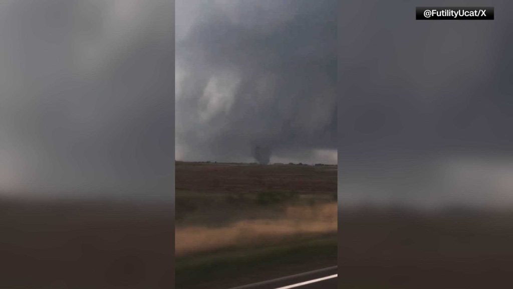
The cellphone video itself was dramatic, with a low, rotating wall cloud and a dark, cone-shaped funnel extending downward that several witnesses described as towering and violent. In many of the clips you can hear people reacting, car doors slamming and the distant roar many associate with intense tornadoes. Those recordings were shared widely enough that authorities used them to confirm the location of the most severe activity and to compare with radar signatures from the storm that moved through the area.
Officials in Palmer and nearby communities issued tornado warnings as the storm approached, urging residents to seek shelter immediately in interior rooms or basements when available. Local volunteer fire departments and county emergency managers mobilized to check on vulnerable residents and scan for damage after the threat passed. At last report, there were reports of downed trees and power lines in several townships northeast of Palmer, and utility crews were dispatched to assess and begin repairs.
The National Weather Service typically sends a damage survey team after reports of large or destructive tornadoes, and that was expected to be part of the next steps here as well. These surveys help determine whether a funnel actually touched down and, if so, how strong the winds were based on the damage footprint. Until that survey is complete, forecasters will describe the event as a possible or probable tornado to avoid overstating the finding without on-the-ground confirmation.
Nebraska sits in a part of the country where spring and early summer can bring rapid severe weather changes, and this event fits that seasonal pattern of rotating storms capable of producing tornadoes. Farmers, rural residents and small towns like Palmer are often the first to capture these events on cellphones because they are on the ground and able to see the storms up close. While dramatic, cellphone footage also plays a practical role: it provides time-stamped visual evidence of what happened and where, which is useful for both officials and insurance claims.
For people who were watching the video or live streams, local leaders emphasized basic tornado safety steps: move to the lowest level of your home, put as many walls as possible between you and the outside, and avoid windows. If you are in a vehicle, the guidance is to seek substantial shelter if possible, otherwise lie flat in low ground away from vehicles while protecting your head. These reminders come up after every warning because quick action still makes the biggest difference in keeping people safe when a tornado is imminent.
In the hours after the event, community members in Palmer organized to check on neighbors who might be isolated or unable to deal with storm cleanup, with local churches and service groups coordinating meal drops and help clearing access to roads. Emergency management officials asked residents to report any new damage they discover so crews can prioritize roads and restore services efficiently. Power companies advised that outages caused by downed lines and damaged transformers could take time to repair given the rural nature of some of the affected areas.
Meteorologists and storm researchers will analyze radar data, eyewitness video and the on-the-ground damage survey to build a full picture of the storm’s path and intensity. That analysis can take days and often changes initial impressions about a storm’s strength and exact track. For now, Palmer residents and nearby communities are focused on recovery and safety, while state and federal agencies stand ready to assist if more significant damage is confirmed.


