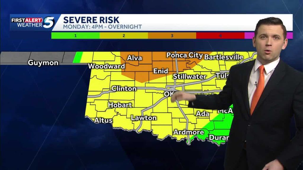
Meteorologist Joseph Neubauer lays out a tightened timeline for a storm threat that starts Monday and spills into Tuesday, with tornadoes, large hail and damaging wind gusts on the table. This piece walks through what the updated timing means for people in the line of the storms, what to watch for from Monday into Tuesday, and practical steps to stay ready. You’ll get clear, no-nonsense guidance straight from the forecast update without panic or fluff.
Joseph Neubauer’s update makes one thing clear: timing is everything when severe weather is involved. The main window opens Monday, and the threat doesn’t simply disappear at midnight. Storms are expected to be active enough that the risk continues into Tuesday for some areas.
That continuation into Tuesday matters because emergencies can catch people off guard during the overnight transition. When dynamics linger, new rounds of storms can redevelop along boundaries left by earlier systems. That means people who thought the worst was over Monday night could see additional severe conditions before dawn.
Forecasters are watching three primary hazards closely: tornadoes, large hail and damaging wind gusts. Each of those threats needs a slightly different level of attention and preparation. Tornadoes demand immediate sheltering, while hail and wind create hazards for vehicles, roofs and power lines.
Timing shifts like the one Neubauer described often reflect how fast the atmosphere is moving and how storms are interacting. If the system stalls or slows, it spreads the risk over a longer period and a wider area. Faster movement concentrates impacts but shortens the window for warning and response.
Morning plans can be especially vulnerable when a risk stretches overnight into the next day. If travel or outdoor work is on the schedule, think ahead and consider options now rather than later. Employers, schools and event organizers should have contingency plans ready to activate if conditions deteriorate.
Watch for local alerts and official warnings tied to changing conditions; those are the cues to move from awareness to action. A watch means conditions are favorable; a warning means take shelter immediately. Neubauer’s timeline update is a heads-up that preparedness should go from theoretical to practical.
Secure loose outdoor items like patio furniture, grills and trash bins before storms arrive to reduce wind-driven damage. Large hail can smash vehicle glass and dent metal quickly, so moving cars to a garage or covered spot is smart if you can do it safely. Planning these small moves ahead of time saves headaches when the sky darkens fast.
For people in rental properties or high-rise buildings, identify your best shelter area now and make sure everyone in the household knows the plan. Interior rooms on the lowest safe floor away from windows are generally the best choice. Keep a basic emergency kit with water, a flashlight and a battery-powered radio accessible.
Power outages are likely where damaging winds are strongest, and those outages can last into Tuesday in places where crews have trouble reaching downed lines. Charge phones and power banks tonight and have a plan for medical devices that need electricity. If you rely on a generator, follow safe operating guidelines to avoid carbon monoxide risks.
Communication plans matter when severe weather interrupts service. Decide how your family will check in if cell networks become unreliable. A simple agreement on meeting places or check-in times can reduce confusion during stressful moments.
Drivers should avoid flooded roadways and be ready for sudden gusts that can push high-profile vehicles. Rain, hail and debris make roads hazardous and can cause slick conditions that last well after the storms pass. If driving is necessary during the threat period, slow down and give yourself extra space.
Pet owners need a plan, too, since animals can become frightened and try to escape in storm conditions. Bring pets indoors early and secure carriers, leashes and any medications. Knowing where you’ll shelter with your animals removes an added layer of stress when warnings come through.
Meteorologists like Joseph Neubauer use evolving data to tighten timelines and highlight where impacts could be greatest, and that’s the value of staying plugged into official updates. Forecasts change as the atmosphere reveals itself, so checking updates regularly helps you react to the most current information. Local emergency managers and weather services will issue watches and warnings tied to those adjustments.
After severe weather moves through, treat downed power lines as live and avoid damaged structures until authorities give the okay. Report outages and hazards through the official channels recommended by local providers to speed response. Photographs for insurance are useful, but only when it’s safe to take them.
In short, Joseph Neubauer’s updated timeline is a reason to pay attention and prepare tonight for storms arriving Monday and that stretch into Tuesday. The combination of tornadoes, large hail and damaging winds calls for a practical checklist: shelter plan, charged devices, secured outdoor items and a way to get real-time warnings. Staying calm, organized and ready is the best defense when the forecast tightens up.


