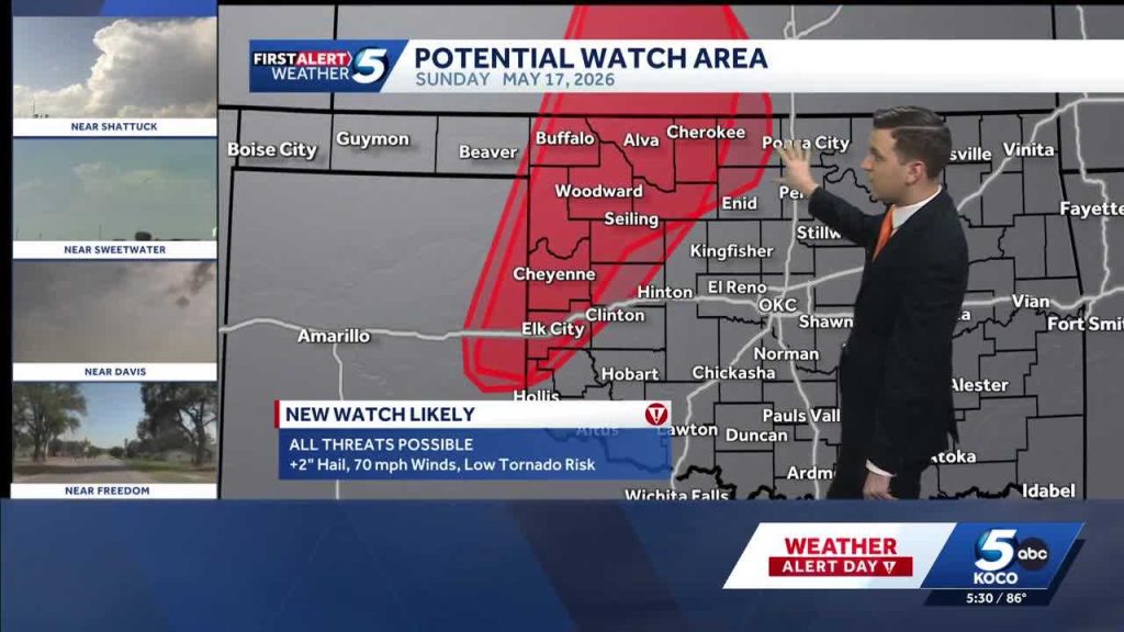
A storm system will move through Oklahoma on Sunday, bringing a low-end tornado threat and a risk of hail across parts of the state, with two alert days expected early next week for a stronger round of storms. This update looks at the forecast setup, where the hazards are most likely, what “low risk” actually means, and practical steps residents can take in places from the Panhandle to southeastern counties.
The atmosphere Sunday will feature warm, humid air streaming north from the Gulf while a disturbance approaches from the west, creating the lift needed for thunderstorms. Strong updrafts can produce hail where storms become more organized, and a narrow corridor of wind shear raises the potential for isolated tornadoes. Timing will generally center on the afternoon into the evening hours, so afternoon plans may need flexibility.
Not every county will see severe weather, and the threat will be patchy rather than statewide. Central and northeastern Oklahoma have a higher chance simply because of how the moisture and dynamics align, but southern and western areas should not ignore watches or warnings. Urban corridors like around Oklahoma City and Tulsa could see brief, intense storms if cells track that way, so residents there should stay alert.
When forecasters say a “low tornado risk,” they mean tornadoes are possible but expected to be isolated and short-lived rather than widespread and violent. These are typically quick spin-ups with little warning lead time, so reliance on real-time alerts is important. That low designation does not mean no risk, and even a single brief tornado can cause localized damage and danger.
The hail threat deserves attention because hail can be the most common form of severe damage with this setup. Expect the possibility of pea- to quarter-size hail where updrafts are strongest, with isolated pockets producing larger stones that dent cars and damage siding or roof shingles. Hail often arrives with strong gusty winds and heavy rain, which can compound hazards and reduce visibility for drivers.
Looking into early next week, meteorologists are calling for a pair of alert days as a more robust system approaches, increasing the scope and intensity of storms across Oklahoma. The timing and exact severity will hinge on subtle shifts in the storm track and the availability of Gulf moisture, so day-to-day updates will refine the threat. If that system phases together, expect a broader swath of stronger storms and a higher chance for damaging winds and larger hail.
Practical preparation is straightforward and useful: have multiple ways to receive warnings, charge phones, and put together a basic emergency kit that includes water, a flashlight, and a first-aid kit. Move vehicles into a garage or away from trees if possible to reduce hail and wind damage, and secure outdoor furniture and loose items that can become projectiles. For those responsible for others, confirm shelter locations and make sure everyone knows what to do if a warning is issued.
Schools, event planners, and local businesses should have contingency plans ready since short-notice warnings can force quick changes. Farmers and livestock owners should move animals to shelter and protect vulnerable equipment, and utility crews should be on alert for potential outages caused by wind or falling limbs. After any storm, document damage with photos and report significant hazards to local emergency management so help and repairs can be prioritized.
Forecasts will evolve as new data comes in, so keep an eye on locally issued watches and warnings and refresh your plan each morning and before heading out in the afternoon. Treat early next week as a higher impact window and avoid making nonessential travel plans if a watch is in effect for your area. Staying proactive and informed is the best way to reduce disruption and keep people safe when severe weather moves through Oklahoma.


