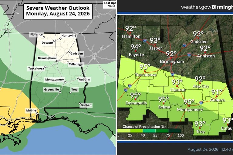
Residents of West Alabama can expect a short reprieve from the extreme heat that plagued the region last week. Forecasts from the National Weather Service show daytime highs staying in the low to mid‑90s for the next several days, rather than the triple‑digit temperatures recorded earlier.
Temperature Outlook
The cooler readings are a modest improvement for families and workers who have been coping with heat‑related challenges. While the mercury will not drop into the 70s, the shift from 100‑plus degrees to the 90‑degree range eases the strain on outdoor activities, school schedules, and energy consumption.
Rain and Storm Risk
Monday, August 24, brings a marginal risk of damaging winds across portions of Alabama, according to the Storm Prediction Center. The only area in West Alabama under this marginal risk is the far southern part of Sumter County, where gusts could reach up to 60 mph.
James Spann, chief meteorologist for the Alabama Weather Network, noted, “The weather won’t change much tomorrow with the highest risk of a shower or storm over the southern half of the state. Moisture moves northward Wednesday, and scattered showers and thunderstorms are likely statewide over the latter half of the week. Most of them will come from noon to midnight.”
What This Means for Residents
Parents can plan outdoor family time with a bit more confidence, knowing that extreme heat will not dominate the next few days. However, the forecast does caution that the weekend may bring a return to hotter temperatures, so staying prepared for additional heat and possible thunderstorms remains wise.
Local businesses, especially those with outdoor patios or construction sites, should monitor the wind advisory for the southern Sumter area and adjust operations as needed to protect staff and customers.
Looking Ahead
While the current outlook offers a brief cooling period, the longer‑range forecast suggests a potential uptick in temperatures as the weekend approaches. Residents are encouraged to stay hydrated, use shade when possible, and keep an eye on local weather updates, especially if they live in the marginal‑risk zone.
For the most current information, check the Alabama Weather Network and the National Weather Service’s online portals.
Original reporting: The Tuscaloosa Thread — read the source article.