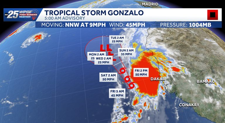
WPBF 25 meteorologists are monitoring Tropical Storm Gonzalo, a tropical wave currently situated in the eastern Atlantic Ocean. According to the National Hurricane Center, the storm is positioned near the Cabo Verde Islands, generating sustained winds of about 45 miles per hour and traveling north‑northwest at roughly 8 miles per hour.
Current conditions and forecast
Forecasters note that a combination of dry air, moderate wind shear, and cooler ocean temperatures is likely to inhibit any significant intensification of Gonzalo this weekend. The storm is expected to remain a tropical storm for the next several days, with no immediate signs of strengthening into a hurricane.
Seven‑day outlook
The National Hurricane Center’s outlook indicates that tropical cyclone formation is not anticipated within the next seven days in the vicinity of Gonzalo. While the system will continue to drift northwestward, the surrounding environment is not conducive to further development at this time.
What residents can do
Although Gonzalo is far from the United States coastline, the agency advises mariners and offshore operators in the Atlantic to stay alert to possible changes in the storm’s track or intensity. WPBF 25 will continue to provide updates as new information becomes available.
Stay informed
For the latest weather alerts and detailed forecasts, readers are encouraged to follow WPBF 25’s on‑air coverage and online platforms. The WPBF 25 News app offers real‑time notifications, ensuring that anyone with an interest in tropical weather can receive timely updates.
As the Atlantic hurricane season progresses, monitoring systems like Gonzalo remains essential for early warning and preparedness. While this particular storm appears limited in its potential, the broader season continues to present opportunities for development, underscoring the importance of staying informed through reliable sources.
Original reporting: WPBF West Palm Beach — read the source article.