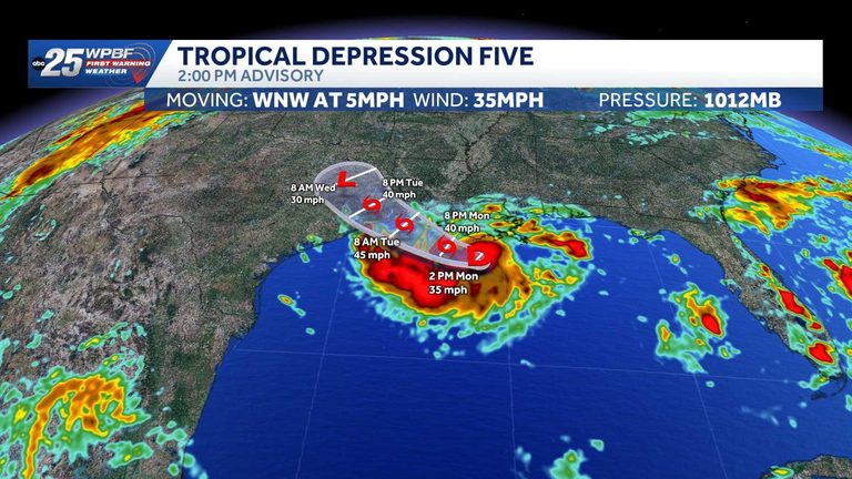
Tropical Depression Five, the latest tropical system of the 2026 Atlantic season, began forming on Monday afternoon in the western Caribbean before moving northward into the Gulf of Mexico. Early satellite imagery showed a well‑defined low‑pressure center with increasing convection, prompting the National Hurricane Center to upgrade the disturbance to a tropical depression late Monday.
Current location and forecast
As of the latest advisory, the center of Tropical Depression Five is situated over the northern Gulf, roughly midway between the coasts of Texas and Florida. Forecast models indicate a slow north‑northwest drift over the next 24 to 48 hours, with the system expected to bring periods of heavy rain and gusty winds to coastal and inland areas alike.
Potential impacts
Although the system has not yet reached tropical storm strength, residents should prepare for the following hazards:
- Rainfall: Forecasts call for 2‑4 inches of rain along the immediate Gulf Coast, with higher totals possible in isolated pockets.
- Wind: Sustained winds are currently near 35 mph, with gusts up to 45 mph. These winds can cause minor tree limb damage and make driving conditions hazardous, especially for high‑profile vehicles.
- Flooding: Low‑lying areas, especially near rivers and bayous, may experience brief flash‑flooding. Residents in flood‑prone zones are advised to monitor local flood‑watch alerts.
- Storm surge: While surge is expected to be modest, a few feet of water could affect vulnerable shoreline communities.
Safety recommendations
The National Weather Service urges Gulf‑coast residents to secure loose outdoor items, keep an eye on local weather updates, and have an emergency kit ready. Those with boats or recreational vehicles should consider moving them to safer locations or securing them against strong winds.
Local emergency management agencies in Texas, Louisiana, Mississippi and Florida have activated their weather‑monitoring desks and stand ready to issue advisories should conditions worsen. Residents can sign up for free alerts through the WP‑25 News app or the official state emergency management websites.
What to watch next
Forecasters will continue to monitor the depression’s intensity. If the system gains strength and reaches tropical storm status, a new set of warnings—including potential tropical‑storm‑force wind advisories—will be issued. The next official advisory is expected within the next six hours.
For the most current information, stay tuned to WP‑25’s weather page, the National Hurricane Center’s website, or the WP‑25 News app, which provides real‑time alerts and safety tips for the Gulf region.
Original reporting: WPBF (Treasure Coast / Hearst) — read the source article.