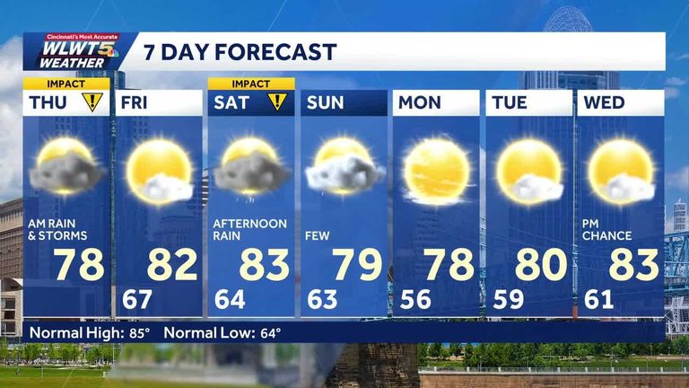
Residents of Cincinnati should brace for a wet start to Thursday, August 20. Meteorologists are forecasting steady rain during the morning rush hour, with the heaviest totals likely in the northern parts of the city. The rain will affect commuters on I‑71, I‑75, and local arterial roads, so drivers are advised to allow extra travel time and use caution on slick surfaces.
Morning conditions
From roughly 6:00 a.m. to 10:00 a.m., rain will be continuous and moderate in intensity. Areas such as Clifton, Walnut Hills, and the neighborhoods north of the river are expected to receive the highest accumulation, potentially exceeding a quarter of an inch before the sun begins to break through. Temperatures will hover in the mid‑70s Fahrenheit, with humidity climbing into the 80 percent range, creating a typical summer rain‑and‑humidity mix.
Midday shift
By lunchtime, the steady rain is projected to weaken and move eastward, leaving much of the city drier. However, isolated showers may linger in pockets, particularly near the Ohio River and in the eastern suburbs. Residents planning outdoor activities or errands should keep an eye on local radar updates, as brief downpours could still develop.
Afternoon outlook
In the afternoon, the weather pattern will become more variable. Expect spotty rain that comes and goes, rather than a continuous downpour. The chance of precipitation will be highest between 2:00 p.m. and 5:00 p.m., but overall coverage will be limited, allowing most of the day to remain mostly dry. Temperatures will rise slightly, reaching the upper 70s, and humidity will gradually decrease as the evening approaches.
Impact on local events
The Thursday night Moeller‑Princeton high school football game is slated for mostly dry conditions, with temperatures in the mid‑70s. Fans should still consider bringing a light jacket in case a stray shower passes over the field. Looking ahead to Friday, the forecast brightens considerably, with high temperatures near 80 °F and largely clear skies—ideal weather for the start of the high‑school football season.
Weekend preview
Two quick cool fronts are expected to move through the region over the weekend. Saturday afternoon will see scattered rain chances, while Sunday may feature a solitary shower in the late afternoon. Temperatures will dip into the low 70s, offering a brief taste of fall‑like weather before the week ahead returns to typical summer warmth.
What to do
- Check live radar and traffic maps before heading out.
- Allow extra travel time during the morning commute.
- Carry an umbrella or rain jacket, especially if you live north of the city center.
- Stay tuned to WLWT’s weather updates for any rapid changes.
Overall, Thursday’s rain will be a short‑term inconvenience for commuters but should not disrupt major community events. Residents can look forward to a drier, warmer Friday and a cooler, slightly wetter weekend as the season transitions toward fall.
Original reporting: WLWT Cincinnati — read the source article.