Residents of central New York should prepare for a shift from rain to snow tonight as a low‑pressure system tracks eastward across Pennsylvania. The system is delivering ample moisture to the region, setting the stage for snow showers after sunset, especially at higher elevations.
Tonight’s weather pattern
Morning rain showers have already arrived across the area, and temperatures remain too warm for snow at most lower‑lying locations. However, once the sun sets, rain will give way to snow showers on the hill south and the higher terrain of the Tug Hill and Adirondack regions. The National Weather Service expects these snow showers to begin around 7 p.m.
Early Friday morning snow
After midnight, temperatures are forecast to drop low enough for snow showers to affect most of central New York. The low‑pressure system will continue moving eastward, pulling the snow bands away during the Friday morning hours. This means that Syracuse and surrounding low‑lying areas will see only a brief window of snow early Friday, limiting overall accumulation.
Snowfall totals
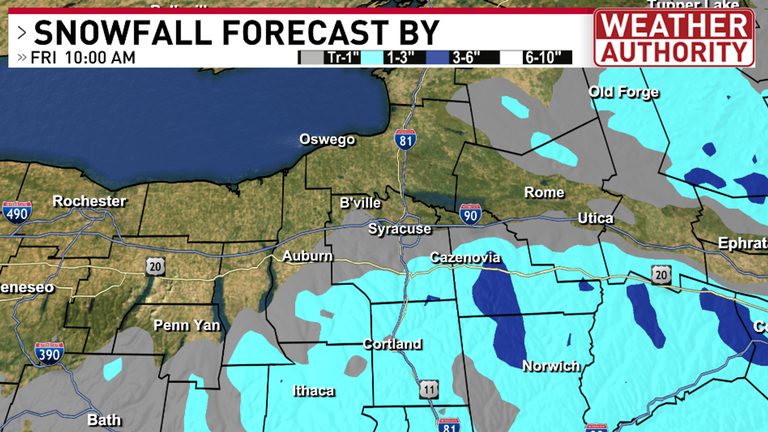
Snowfall forecasts through 10 a.m. Friday show modest totals, with higher elevations around Syracuse expected to receive slightly heavier amounts. Most of the snow will fall on colder surfaces, which helps preserve the flakes and increase accumulation in those spots.
What to expect
- Rain showers continue this evening at lower elevations.
- Snow showers develop after 7 p.m. on hill south, Tug Hill, and Adirondack heights.
- After midnight, snow showers spread across central New York, but will diminish by Friday morning as the system moves east.
- Limited snowfall for Syracuse, with only a few early‑morning hours of snow.
- Higher elevations around Syracuse may see slightly higher totals.
For the most up‑to‑date forecast and live local radar, click the link provided by the National Weather Service.
Original reporting: CNY Central WSTM (Sinclair) – local — read the source article.