South-Central Texas is in the spotlight as an upper-level disturbance scoots in from Mexico, nudging scattered storms into places like Eagle Pass and Laredo and raising the chance for severe weather south of Highway 90. This forecast covers tonight’s overnight activity through a mostly sunny Saturday afternoon, then the heat and evening storm chances for Mother’s Day with expected clearing by Monday morning. I’ll explain timing, hazards, what to watch for if you have outdoor plans, and where to find quick weather resources to keep tabs on moving cells.
The overnight picture looks unsettled as upper-level energy slips into South-Central Texas from Mexico, and that lift is enough to spark scattered showers and thunderstorms between midnight and the early morning. Most of the thunderstorm activity is expected to focus along the corridor from Eagle Pass to Laredo, where the atmosphere will be most receptive. Storms could become severe in spots, especially south of Highway 90, so localized damaging winds and intense lightning are possibilities.
Timing matters: the bulk of activity is forecast from about 12am to 7am, though isolated cells could linger a little longer in favors. Heavy downpours in slow-moving storms will create pockets of brief but intense rainfall, and that raises the risk of nuisance flooding on low-lying roads. Drivers should treat standing water seriously and avoid attempting to cross flooded roadways during these nighttime storms.
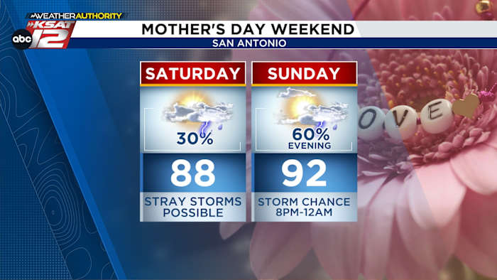
On Saturday the overall trend is toward sun. Expect dry and mostly sunny conditions through the day, with highs warming under abundant sunshine and limited cloud cover. From roughly 3pm to 7pm the atmosphere will destabilize enough to allow a few random pop-up showers or storms, but coverage should be spotty and hit-or-miss rather than widespread.
Mother’s Day is shaping up to be warm and sunny during the daytime, with high temperatures climbing into the lower 90s across the region before the evening change arrives. A cold front is forecast to sweep through after sunset, and that boundary will likely trigger more organized storms after about 7pm. Those evening storms could produce strong gusts and heavy rain for a time, but most of the precipitation should exit the area by Monday morning, leaving a drier stretch to follow.
If you have outdoor plans for Saturday or Mother’s Day evening, consider a simple contingency: move events earlier in the day when it will be sunniest and hottest, and have an indoor fallback if storms fire up after sunset. Keep a weather radio or a reliable app handy to get real-time warnings, and keep children and pets away from exposed flood-prone areas during heavy downpours. Remember that lightning can strike well away from the storm center, so seek shelter at the first sign of thunder.
Forecast confidence is moderate for the timing and placement of these storms, with the highest certainty for the overall pattern—overnight scattered storms tonight, a mostly dry Saturday with isolated afternoon pop-ups, and a more significant chance of storms after sunset on Mother’s Day. Forecast details could shift as the upper-level energy and the front interact, so expect updates and short-term adjustments from local forecasters. Looking beyond the weekend, a drier, warmer trend is expected to set up next week as the region rebounds from this brief unsettled period.
QUICK WEATHER LINKS
Use these resources to stay current during tonight’s and the weekend’s forecast swings. They offer live radar, hour-by-hour outlooks, and tools to share your weather photos with local meteorologists.
- WATCH LIVE: Doppler Radar
- Hourly and 10-Day Forecast
- Download FREE Weather App for up-to-the-minute forecasts and livestreams from local meteorologists
- Share Your Weather Photos with local teams to help spot flooding and storm impacts