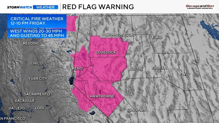
Residents of Northern Nevada should prepare for heightened fire danger this Friday as the National Weather Service has issued a Red Flag Warning for several counties. The warning covers Southern Washoe, Lyon, Carson City, Douglas, Pershing, Churchill and Mineral counties from noon through 10 p.m.
Wind and humidity create critical conditions
Wind gusts are expected to reach 40‑45 mph in the most exposed areas, with lower gusts east of Reno. Even before the official start at noon, gusts will already be in the 20s, and breezy conditions will persist into Thursday night with gusts in the teens to 20 mph. Relative humidity could drop to as low as 17 %, further increasing the risk of rapid fire spread.
What’s driving the fire danger?
A large trough moving through the Pacific Northwest, combined with a surface front moving across Northern Nevada on Friday, is responsible for the strong winds. The trough is already bringing high‑level clouds to Northern California and rain to Seattle, but it will stay well north of the Truckee Meadows, leaving the area dry. Temperatures are expected to cool slightly, but the pressure gradient will tighten, boosting wind speeds.
Safety recommendations
Most fires in the region are human‑caused, so authorities urge residents to exercise extreme caution. Avoid outdoor burning, keep vehicles and equipment free of debris, and stay alert for any fire‑related emergencies. Local fire departments will be on heightened alert throughout the warning period.
Looking ahead
While Friday will see the strongest winds, the weekend is expected to be breezy but less severe. No rain is forecast for the Truckee Meadows, so humidity will remain low. Residents should continue to stay fire‑aware and follow updates from local authorities.
Original reporting: 2news.com — read the source article.