Residents of Boston and surrounding towns should prepare for another muggy day as warm air remains in place for the next couple of days. High temperatures are expected to approach, though not exceed, 80 degrees Fahrenheit, while humidity will peak today, making it feel especially sticky.
Rain Expected North of Boston
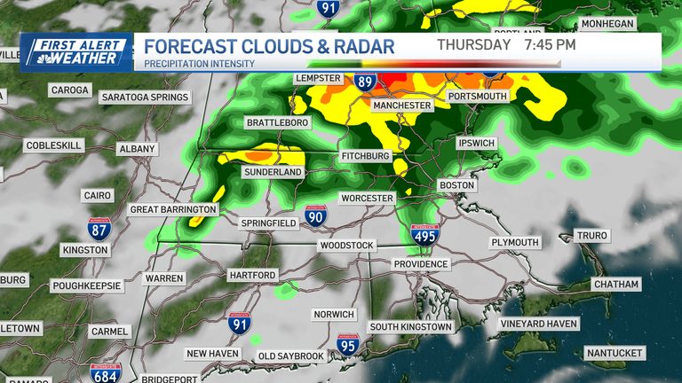
Cloud cover will increase this afternoon, but showers are likely to stay to the north. By “north” we mean areas north of the Mass Pike, specifically towns and cities north of Littleton, Concord, and Danvers. The heaviest rain will be farther north, from Newburyport up to Nashua, where accumulations could reach up to an inch of water, with some forecasts suggesting even higher amounts.
Elsewhere, including Boston proper, the rain will be lighter—just a few passing showers with minimal totals. The rain is expected to clear late tonight, giving way to sunshine and less humid air tomorrow.
Temperature Outlook
Temperatures will have one last surge into the 70s before falling into the 60s over the weekend. A few showers are likely to return to New England on Sunday, marking a damp, cool autumn day.
While rainfall will not be particularly heavy this time around, it will be enough to keep surfaces wet at Gillette Stadium and other outdoor venues.
Looking Ahead to Next Week
The forecast for next week is more uncertain. A wet front near New York City could influence the region, but it may remain far enough away to keep most of the week dry. Current guidance leans toward a mostly cool, dry stretch, though forecasters remain vigilant for any shifts.
Overall, residents should expect today’s muggy heat, moderate rain to the north, and a cooler, drier pattern early next week, with a chance of additional showers on Sunday.
Original reporting: NBC10 Boston — read the source article.