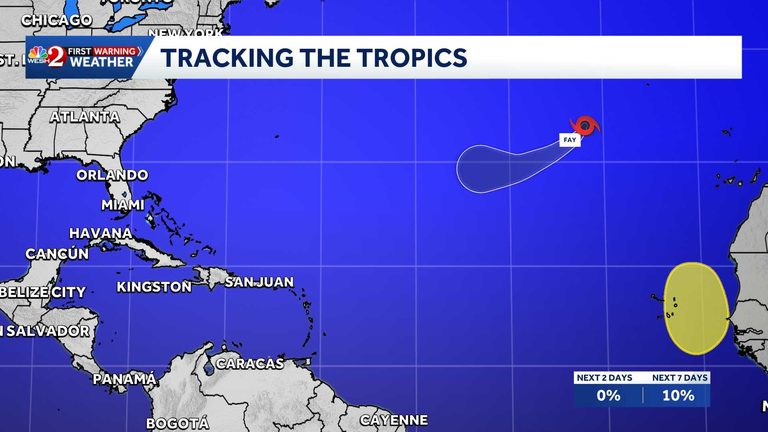
The National Hurricane Center (NHC) announced today that a new tropical wave is expected to emerge off the western coast of Africa by Wednesday. The system is projected to travel westward toward the Cape Verde Islands later this week. While the NHC notes that any development should be gradual, it assigns a 20% chance that the wave could develop into a tropical cyclone within the next seven days.
Current outlook for the wave
According to the latest advisory, the probability of formation in the next 48 hours is zero percent, reflecting the expectation that the disturbance will need more time over warm Atlantic waters before it can organize. The NHC’s forecast model shows the wave moving at a moderate pace, staying well north of the main shipping lanes and keeping the immediate threat to the United States low for the time being.
Tropical Storm Fay continues to weaken
In the same bulletin, forecasters reported that Tropical Storm Fay is steadily losing intensity. Fay is expected to continue weakening over the next day or two and could transition into a post‑tropical cyclone shortly. The storm’s wind fields are shrinking, and satellite imagery shows a diminishing central convection pattern.
Despite the weakening trend, the NHC advises residents in the path of Fay to remain vigilant. Local National Weather Service offices will continue to issue watches and warnings as needed, and the public should stay tuned to official updates.
What Central Florida residents should do
WESH 2’s First Warning Weather team, led by Chief Meteorologist Tony Mainolfi, reminds Central Florida viewers to keep an eye on the latest forecasts. The team recommends the following precautions:
- Secure outdoor items that could become projectiles in strong winds.
- Review emergency kits and ensure they contain essential supplies.
- Monitor local alerts via the WESH 2 News app for real‑time updates.
While the new wave is still far from land, the Atlantic hurricane season remains active, and vigilance is essential. The NHC’s proactive monitoring helps provide early warning, giving families and communities the time they need to prepare.
Looking ahead
Forecasters will continue to assess the wave’s potential as it approaches the Cape Verde Islands. If the system shows signs of organization, the NHC will update its probability figures and may issue a tropical depression advisory. In the meantime, the focus remains on Fay’s gradual dissipation and ensuring that any residual impacts are communicated clearly to the public.
For the most accurate Central Florida weather information, stay with WESH 2 online, on‑air, or through the Very Local app. The First Warning Weather team—including Tony Mainolfi, Eric Burris, Cam Tran, Victoria Wisniewski, and Luke Vickery—will provide ongoing coverage throughout the season.
Original reporting: WESH Orlando — read the source article.