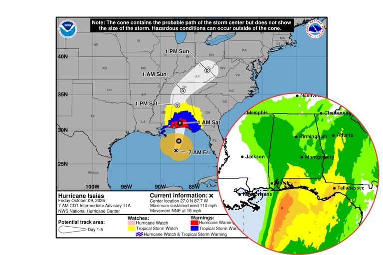
Hurricane Isaias is now classified as a Category 3 storm, with maximum sustained winds of 110 mph and a central pressure of 958 mb. While the system is expected to weaken to a Category 2 at landfall this evening, its fast‑moving north‑northeast track will bring significant weather to West Alabama.
What residents can expect
James Spann, chief meteorologist for the Alabama Weather Network, notes that the core of the storm will move quickly through the region tomorrow morning. “The main wind, rain, and storm‑surge impacts will be along and to the east of the circulation center,” he said, underscoring the importance of preparing for severe conditions even outside the immediate landfall zone.
The National Weather Service in Birmingham outlines the specific hazards:
- Wind: Gusts of 50‑60+ mph are forecast from late tonight through Saturday, capable of downing trees and power lines across the area.
- Rain: Accumulations of 1.5‑4 inches are expected, with localized totals up to 5 inches. Urban neighborhoods, low‑lying terrain, and areas with poor drainage could see flash flooding.
- Tornadoes: Isolated tornadoes may develop along and east of Interstate 65 on Saturday, with the greatest risk near the Georgia state line. The region sits in a Level 1‑2 out of 5 tornado risk.
Current watches and warnings
County‑level alerts have already been issued:
- Bibb, Greene, Hale, Perry, Pickens, Sumter, Tuscaloosa: Tropical Storm Watch and Flood Watch from Friday 7 p.m. to Sunday 7 a.m.
- Fayette, Lamar, Walker: High Wind Watch from Saturday 1 a.m. to Sunday 1 a.m., plus Flood Watch for the same period.
These watches remain in effect until the storm moves out of the coverage area. Residents should stay tuned to local media and the Townsquare Media Weather Center, which will continue providing updates throughout the event.
Preparation tips
Authorities recommend the following actions:
- Secure outdoor objects that could become projectiles in high winds.
- Charge mobile devices and gather emergency supplies, including water, non‑perishable food, flashlights, and batteries.
- Review evacuation routes and shelter locations if a flood warning is issued for your area.
- Avoid travel on flooded roads and heed any road‑closure announcements.
While the storm poses serious risks, the coordinated response from meteorologists, the National Weather Service, and local emergency managers aims to keep West Alabama residents safe. Stay informed, follow official guidance, and take proactive steps to protect your family and property.
Original reporting: The Tuscaloosa Thread — read the source article.