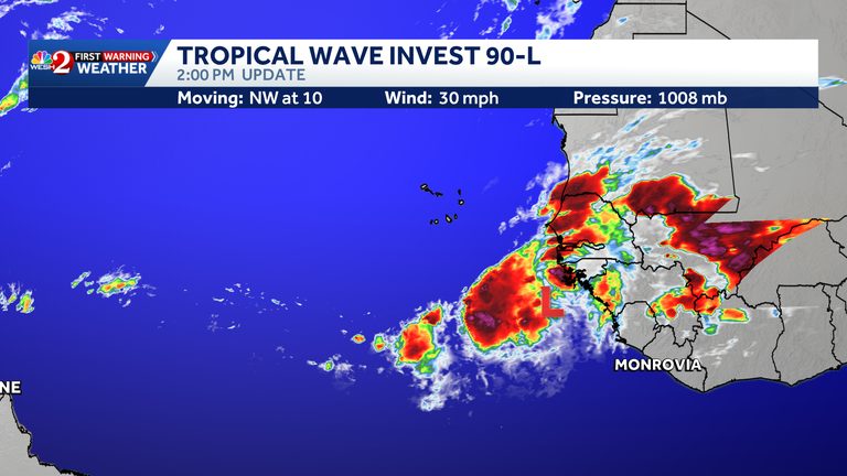
The National Hurricane Center (NHC) announced today that a tropical wave emerging off the west coast of Africa has been designated Invest 90-L. The system is expected to travel westward across the Atlantic, where an area of low pressure could develop within the next day or two.
Potential development and forecast
Forecasters say Invest 90-L could briefly reach tropical depression status on Thursday or Friday. However, strong upper‑level winds are projected to inhibit further intensification, limiting the chance of a stronger storm by the weekend.
Current model guidance gives the system a 50% chance of forming into a tropical cyclone within the next 48 hours, and the same 50% probability over the next seven days. These numbers reflect the inherent uncertainty in early‑season tropical development.
Impact on the Cabo Verde Islands
Although the wave poses no immediate threat to Central Florida, the NHC cautioned that the Cabo Verde Islands could experience gusty winds, periods of heavy rain, and possible flash flooding by Friday as the system passes nearby. Residents are advised to monitor local forecasts and be prepared for sudden downpours.
What Central Florida viewers need to know
WESH 2’s First Warning Weather team emphasized that Invest 90-L is not a danger to Central Florida at this time. The station will continue to provide updates through its online platforms and mobile app, ensuring that viewers receive the most accurate and timely information.
For those in Central Florida who want to stay informed, the WESH 2 News app offers real‑time alerts and detailed forecasts. The First Warning team, including Chief Meteorologist Tony Mainolfi, Eric Burris, Cam Tran, Victoria Wisniewski, and Luke Vickery, will track the system’s progress throughout the week.
Looking ahead
Invest 90-L joins a busy Atlantic hurricane season, with several other disturbances already being monitored. The NHC will continue to issue advisories as the wave evolves, and any changes in intensity or track will be reflected in future outlooks.
Residents of the Cabo Verde Islands and anyone with interests in the Atlantic basin should keep an eye on official updates, especially if the system shows signs of strengthening. For Central Florida audiences, the focus remains on routine weather monitoring and preparedness for any local impacts that may arise later in the season.
Original reporting: WESH Orlando — read the source article.