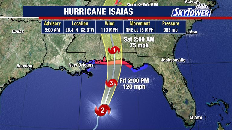
Hurricane Isaias is rapidly gaining strength on Friday morning, with sustained winds of 110 mph that place the storm just shy of major Category 3 status. The system is moving westward toward the northern Gulf coast, prompting local authorities to activate a series of warnings and preparedness measures.
Current warnings and expected impacts
Hurricane warnings are in effect from Ocean Springs, Mississippi, across the Gulf Coast to the Bay/Gulf County line in the Florida panhandle. Residents in the warning zone are being urged to secure property, stock essential supplies, and stay tuned to official updates.
Storm surge is projected to reach 5 to 7 feet near the storm’s center and east of the eventual landfall point. In Florida, surge heights of 1 to 3 feet are expected from Citrus to Pinellas counties beginning Friday and persisting through the weekend. These surge levels could cause coastal flooding, especially in low‑lying neighborhoods and barrier islands.
Forecasted weakening and rain outlook
Forecasters anticipate that wind shear – a change in wind speed or direction with height – may cause some weakening of Isaias as it approaches the northern Gulf coast. Even with potential weakening, the storm will remain dangerous, with high winds, heavy rain, and the possibility of tornadoes.
Heavy tropical downpours are likely to continue through the weekend, bringing additional localized flooding to parts of the Florida coastline. By Monday, the system is expected to move offshore, allowing drier air to settle in and humidity levels to drop, bringing clearer skies and more sunshine early next week.
Local response and preparedness
Emergency management officials in Florida and Mississippi have activated response teams and are coordinating with the National Weather Service, the Coast Guard, and local first‑responders. Shelters are being prepared for residents who may need to evacuate low‑lying areas, and utility crews are on standby to address potential power outages.
Residents are encouraged to review evacuation routes, keep mobile phones charged, and have an emergency kit that includes water, non‑perishable food, medications, and important documents. Those living in mobile homes, on the water’s edge, or in flood‑prone zones should consider relocating to higher ground until the threat subsides.
What’s unknown
Officials have not yet pinpointed the exact timing or precise landfall location for Hurricane Isaias along the Gulf coast. The severity of localized flooding remains uncertain, as it will depend on the storm’s exact path, the speed of its forward motion, and the condition of local drainage systems.
Authorities will continue to monitor the storm’s evolution and provide updates as more information becomes available. Residents should stay informed through official channels such as the National Weather Service, local emergency management websites, and trusted news outlets.
Stay safe
While Hurricane Isaias poses a serious threat to the northern Gulf coast, the coordinated response of local, state, and federal agencies aims to minimize risk to life and property. By heeding warnings, preparing homes, and staying informed, Floridians and Mississippians can better protect themselves and their families as the storm moves inland.
Original reporting: Tampa Bay Florida News (HLL/CB) — read the source article.