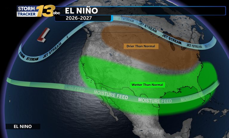
Colorado residents can look forward to a wetter winter than usual, according to the latest long‑range outlook from the National Weather Service (NWS). Meteorologists say the upcoming El Niño is shaping up to be the strongest on record, and historical patterns suggest it will bring normal to above‑normal precipitation to the southern part of the state.
What the data show
Past El Niño events in 1982‑83, 1997‑98 and 2015‑16 all produced similar outcomes in Colorado. In each of those winters the region experienced a season of at least average, and often above‑average, rainfall and snowfall. The current set‑up mirrors those historic patterns, giving forecasters confidence in a wet outlook.
Local impacts expected
“I think we will have a good winter over the Plains with above‑normal precipitation, again that is what has suggested in the past years since the 1980s,” said Klint Skelly, a Warning Coordinator Meteorologist with the NWS office in Pueblo. Skelly added that while the plains and eastern mountains are likely to see the bulk of the moisture, the area near the Continental Divide and central Colorado could experience below‑normal precipitation.
For Colorado Springs residents, the timing aligns with the typical first snowfall window around October 27. That means the city may see early snow events this month, followed by a sustained period of rain and snow through the winter months.
Why it matters to families and communities
A wetter winter can benefit farmers, ranchers, and water‑resource managers who rely on snowpack to replenish reservoirs and aquifers. It also reduces the risk of drought‑related restrictions later in the year, helping families maintain reliable water supplies for household use and irrigation.
At the same time, local authorities will need to prepare for the usual challenges that come with increased precipitation: road maintenance, potential flooding in low‑lying areas, and ensuring that schools and businesses have contingency plans for winter weather disruptions.
What to watch
- Monitor local NWS alerts for heavy rain or snow events, especially in the foothills and river valleys.
- Stay informed about road conditions on mountain passes, which can become hazardous with early snow.
- Farmers and ranchers should coordinate with county extension offices to plan water‑use strategies that take advantage of the expected snowpack.
Residents can stay up‑to‑date on the evolving forecast by following the KRDO13 app, which provides real‑time weather alerts and local news.
Original reporting: KRDO (Colorado Springs metro) — read the source article.