Collin County officials are moving the Southeast segment of the proposed Outer Loop closer to final design, a step that could soon affect daily commutes and future development for Wylie and surrounding communities.
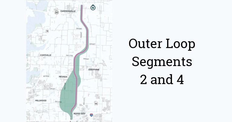
According to the Princeton Herald, the county held a public meeting on Oct. 27 at Leland Edge Middle School in Nevada and posted a virtual presentation online. The meeting covered Segments 2 and 4 of the Outer Loop, a roughly 14‑mile stretch that runs from County Road 656 northeast of Farmersville to the Collin‑Rockwall County line northwest of Royse City.
The Murphy Monitor notes that the study, which began in summer 2024, is slated to finish in late 2026 or early 2027. Engineers are finalizing a schematic design and a Local Environmental Document (LED) for the county‑selected “Pink Alignment,” a western shift of the previously identified Technically Preferred Alignment.
Both outlets report that the preferred alignment still may shift as engineering work continues. The proposed right‑of‑way would be about 500 feet wide, and the LED will evaluate impacts on residences, businesses, community facilities, and archaeological, historical, cultural and biological resources.
Once the Collin County Commissioners Court approves the LED, the county plans to move into detailed design and begin acquiring the land needed for the corridor. The acquisition phase is expected to take several years, according to both sources.
Construction is envisioned in phases. The initial phase would build a two‑lane frontage road carrying traffic in both directions, designed for 45 mph, once funding is secured. The county could construct both frontage roads simultaneously if traffic demand and funding justify it. Freeway main lanes, designed for 70 mph, would be added later as population growth and travel demand increase.
Drainage plans call for runoff to be directed away from nearby neighborhoods via engineered grassy ditches or channels and appropriately sized culverts. Decisions on roadway lighting, including size and spacing of lights, have not yet been made.
The Southeast segment will eventually become part of a larger 55‑mile Outer Loop that would extend from the Denton County line through Celina, Weston, Anna, Melissa, Farmersville, Josephine and Royse City, linking with a regional outer‑loop system across Denton, Collin, Rockwall, Kaufman and possibly Ellis counties. Collin County is also advancing planning for Segments 1 and 5 and studying a north‑south freeway between Princeton and State Highway 121.
Residents and property owners can follow updates and view alignment maps at CCOL‑SE.com, where the county says maps will be refreshed as the project progresses.
What’s next: The LED will be presented to the Commissioners Court for approval later this year. After approval, detailed design work will continue, and the county will begin the multi‑year right‑of‑way acquisition process. Community members are encouraged to monitor the website for upcoming public‑input opportunities.
Sources: princetonherald.com, murphymonitor.com