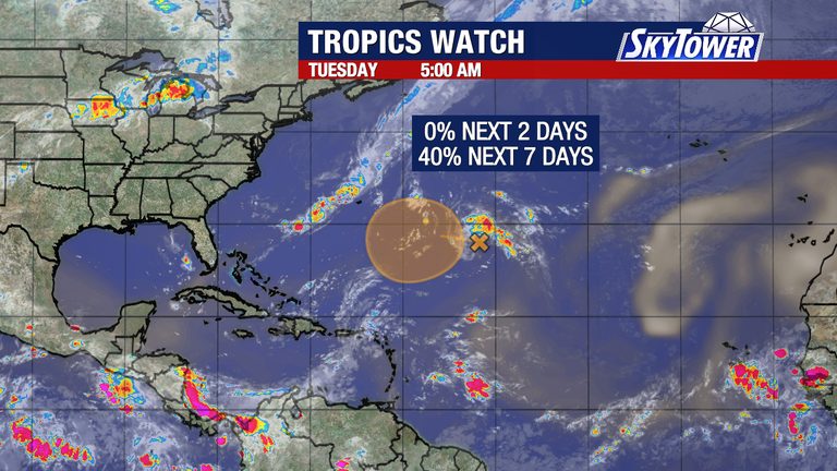
Early Tuesday morning, meteorologists observed a disturbed area of weather in the Central Atlantic that appears slightly more organized than earlier today. The system is situated in an isolated pocket of light wind shear, which has allowed it to maintain a modest level of structure.
Limited window for development
Despite this brief improvement, experts caution that the window for any further growth is narrow. Surrounding atmospheric conditions—including stronger winds and higher shear—are expected to become unfavorable soon, limiting the system’s ability to intensify.
Computer models indicate that even if the disturbance manages to tighten its circulation, it will likely turn northward over open waters without gaining the strength needed to become a tropical storm. No strong model support exists for a significant upgrade at this time.
What remains uncertain
Forecasters have not yet confirmed whether the disturbance will develop a closed circulation before stronger winds tear it apart. The National Hurricane Center continues to monitor the system closely, but the consensus is that any further organization will be short‑lived.
In addition to this system, meteorologists are keeping an eye on the broader Atlantic basin. However, they do not anticipate any additional tropical development over the next several days.
Implications for the Gulf Coast and beyond
While the current disturbance is expected to stay well away from land, residents along the Gulf Coast and the Eastern Seaboard are reminded to stay informed about any updates. Even weak systems can bring increased surf, rip currents, and scattered showers to coastal areas.
The National Hurricane Center will issue regular updates as the situation evolves. Anyone planning outdoor activities near the coast should monitor local forecasts and heed any advisories from emergency management officials.
Looking ahead
As the Atlantic hurricane season progresses, the pattern of isolated, short‑lived disturbances is expected to continue. The key takeaway for the public is to remain vigilant, stay prepared, and rely on official sources for the most accurate information.
Original reporting: Tampa Bay Florida News (HLL/CB) — read the source article.