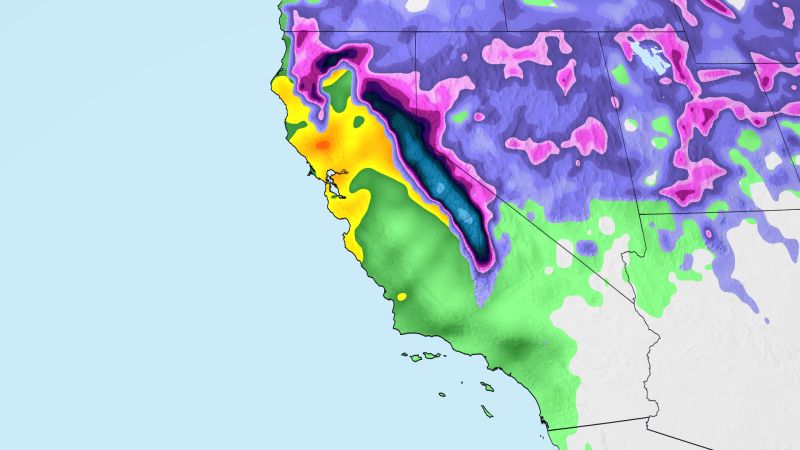
California residents should prepare for a significant weather event this week as an atmospheric river moves onto the state, bringing widespread flooding rain and heavy mountain snow. The National Weather Service in Los Angeles called it the first storm of the season with truly widespread moderate to heavy rain and high‑elevation snow.
Rainfall and Flood Risks
Heavy downpours are expected to begin early Wednesday morning across the Bay Area and Central Coast. The Weather Prediction Center has placed these regions under a Level 2 of 4 flood risk, with forecast totals of 1‑2 inches of rain and localized amounts of 3‑4 inches, especially in coastal mountain ranges. The most intense rain could fall within a three‑to‑six‑hour window, followed by lingering showers through Thursday.
Further inland, the Sacramento Valley and Sierra Nevada foothills are likely to see at least 1 inch of rain, with some areas receiving 2 inches or more on Wednesday and Thursday. Southern California, including Los Angeles and San Diego, will face a Level 2 flood risk on Thursday, with 1‑3 inches of rain possible and higher amounts of 3‑5 inches on mountain slopes.
Snow and Travel Impacts
Cold air accompanying the storm has prompted winter storm watches for heavy snow in the Sierra Nevada. Snowfall rates of 1‑2 inches per hour are expected, with accumulations of at least 2 feet above 5,000 feet and possible depths of 3 feet or more in higher locations. Mountain passes such as Interstate 80 at Donner Pass will experience dangerous travel conditions, including gusty winds and reduced visibility.
Snow could also fall as low as 4,000 feet, affecting ski resorts and creating travel headaches for motorists. Drivers are urged to exercise caution on mountain roads and be prepared for possible road closures.
Wind and Power Outages
Strong winds of 30‑45 mph are forecast for parts of the Bay Area and interior Northern California on Wednesday and Thursday. These gusts could down trees and cause scattered power outages.
Additional Hazards
Urban flooding is possible, and recently burned areas remain vulnerable to flash flooding and debris flows. Burned soil absorbs less water, increasing the risk of runoff and landslides on canyon roads.
Residents should stay informed through local weather updates, heed any flood warnings, and avoid travel on hazardous routes when possible.
Original reporting: KRDO (Colorado Springs metro) — read the source article.