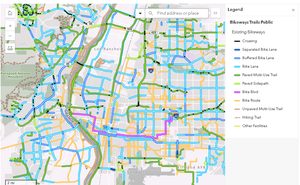
Residents of Albuquerque can now access an updated map detailing the city’s extensive network of bikeways and trails. This new map, released by the City of Albuquerque, highlights the latest additions to the more than 400 miles of paved and unpaved paths available to cyclists.
Comprehensive Cycling Routes
Jennifer Turner, director of the city’s Department of Municipal Development, emphasized the continuous growth of Albuquerque’s biking infrastructure. ‘Every year we add more trails and paths, and this map features all the newest lanes, paths, crossings, and even Rail Trail segments,’ she stated. The map is designed to assist everyone from daily commuters to weekend explorers in finding the best routes for their cycling needs.
The map also includes valuable information such as the locations of arroyos, trailheads, and ART bus connections where bicycles can be loaded onto buses. Additionally, it features the popular 50-mile loop, a favorite among local cyclists.
Accessing the New Map
To obtain a copy of the new map, residents can call 311 or visit the Esperanza Bicycle Safety Education Center. Maps are also available at the city’s senior and multi-generational centers, libraries, and City Hall. For those who prefer digital access, more information can be found online at www.cabq.gov/parksandrecreation/recreation/bike/bike-map.
This initiative underscores Albuquerque’s commitment to promoting outdoor activities and providing resources that support a healthy, active lifestyle for its residents.
Original reporting: KOAT Albuquerque — read the source article.


