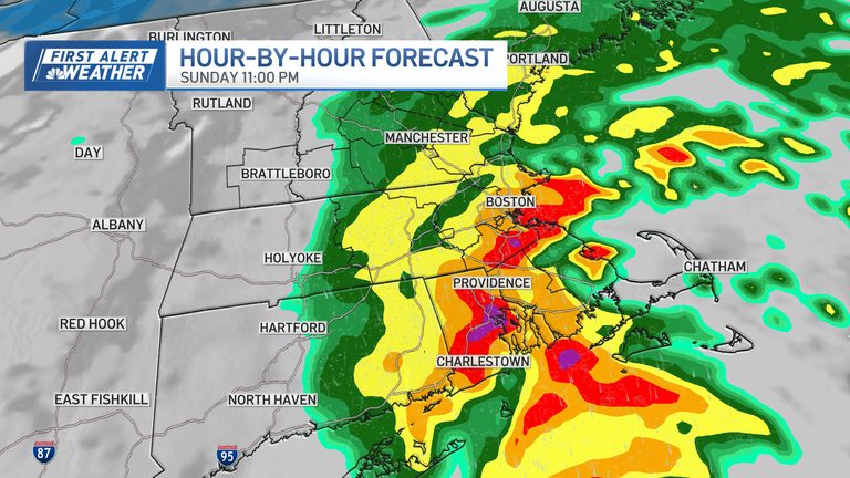
Residents of Massachusetts should prepare for a wet and windy Thursday night as a fast‑moving rain system moves into the region this afternoon. Meteorologists expect rain to become widespread late this afternoon, with heavier bands developing overnight and persisting into early Monday.
Rain totals and flooding risk
Across the state, anywhere from a half inch to two inches of rain is possible through Monday morning. The greatest amounts are likely along the Cape and South Shore, where localized street flooding could occur. While the storm is moving quickly, the sheer volume of rain means drivers should exercise caution on roadways, especially in low‑lying areas.
Wind and coastal impacts
North‑east winds will pick up after dark, with gusts ranging from 25 to 45 mph. The strongest gusts are expected on Cape Cod and the islands, raising the potential for rough seas and minor coastal splash‑over, particularly during Monday’s high tide.
Short‑term outlook
The good news is that rain and wind should begin to subside by Monday morning, giving way to clearer skies and improving conditions throughout the day. Temperatures will stay modest, with highs only reaching the 40s. Overnight lows will dip into the teens and 20s in many communities, setting the stage for colder weather later in the week.
Thanksgiving travel and the next storm
Colder air moving in early next week will make the upcoming Thanksgiving travel period more challenging. A second coastal storm is projected to arrive late Wednesday night into Thanksgiving Day. This system could bring another round of heavy rain, strong coastal winds and hazardous marine conditions. In the higher elevations of the interior, there is a chance of some snow or ice at the onset, though the majority of the storm will be rain across Southern New England.
Coastal flooding is also a concern with the second storm, especially as it coincides with astronomically high tides. Residents in flood‑prone areas should stay alert for local advisories and be ready to protect property and personal safety.
What to do now
Stay tuned to local weather updates and heed any warnings from the National Weather Service. Drivers should allow extra travel time, avoid low‑lying roads that may flood, and secure outdoor items that could be blown by strong gusts. Those planning Thanksgiving travel should monitor conditions closely and consider alternate routes if necessary.
Overall, while the first storm will bring inconvenient rain and wind, it is expected to clear quickly, giving residents a brief window of better weather before the more impactful Thanksgiving‑week storm arrives.
Original reporting: NBC10 Boston — read the source article.