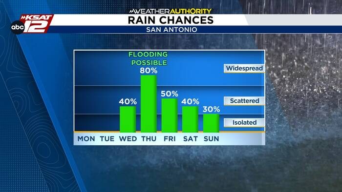
San Antonio residents should prepare for a wet spell later this week. While today remains hot with highs in the mid‑90s and a heat index near 100°, the forecast shifts dramatically by Wednesday night as a slow‑moving front approaches.
Wednesday Night – Flooding Possible
By Wednesday evening, a line of storms is expected to develop along the front and move eastward toward the city. The system is capable of producing strong thunderstorms, but the primary concern is heavy rainfall. Current models show the storm line reaching San Antonio just before dawn on Thursday, bringing the potential for localized flooding.
Thursday – Continued Rain Threat
Storms are projected to persist through at least the first half of Thursday. If the same areas experience repeated rain, flooding could become a serious issue. Local authorities will be monitoring river levels and drainage conditions closely, and they may issue flash‑flood warnings if needed.
Friday and the Weekend
Showers may linger into Friday and could extend into the weekend, keeping temperatures cooler than earlier in the week. Residents should stay alert for updated forecasts and any advisories from the National Weather Service.
What Residents Can Do
- Keep an eye on local weather alerts and flash‑flood warnings.
- Avoid driving through low‑lying areas that may become inundated.
- Secure outdoor items that could be moved by strong winds.
- Check that sump pumps and drainage systems are clear and functional.
By staying informed and taking simple precautions, San Antonio families can protect their homes and stay safe during this period of heavy rain.
Original reporting: San Antonio, TX News (HLL/CB) — read the source article.