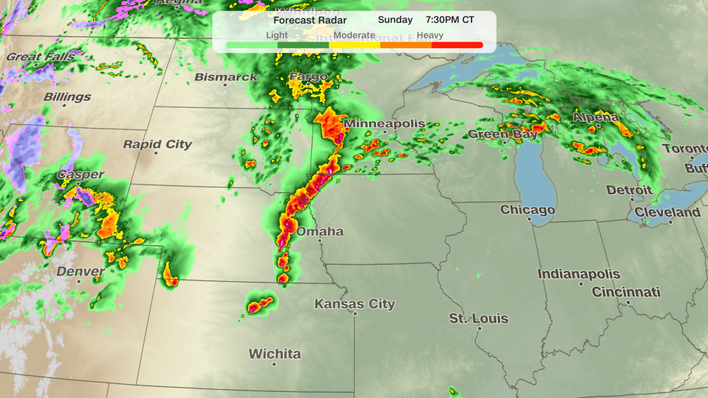
Meteorologist Taylor Ward of CNN warns that the central United States is bracing for a volatile stretch of severe weather, with the Plains and Midwest at particular risk. After a quiet start to May, the atmosphere has loaded up and is primed to produce strong thunderstorms beginning Sunday and continuing through Tuesday. Officials are signaling the potential for intense tornadoes, with EF3-strength twisters possible in the most unstable zones.
The setup is classic severe-weather theater: warm, humid air surging north from the Gulf collides with a strong, fast upper-level jet and steep wind shear. That combination favors rotating supercell thunderstorms, the storm type most likely to spin up significant tornadoes. Forecast models are showing multiple rounds of storms rather than a single, isolated episode, which raises the threat window and complicates response.
Timing matters because these storms will arrive in waves and could occur during the evening and overnight hours when people are asleep and less likely to get warnings. The highest concern begins Sunday evening and can redevelop through Monday and into Tuesday across portions of the Plains into the Midwest. Nighttime tornadoes are especially dangerous, so staying alert after dark is critical for those in the watch areas.
Expect a mix of hazards beyond tornadoes. Large, destructive hail and damaging straight-line winds will accompany many of the stronger cells, and locally heavy rain could produce flash flooding, particularly where storms train over the same route. Power outages and downed trees are likely outcomes of intense wind and hail impacts, and those secondary effects can strand communities even if a tornado misses a town center.
Local National Weather Service offices will issue tornado watches to highlight regions where conditions are favorable, then tornado warnings for specific storms that exhibit rotation on radar or produce confirmed tornadoes. Watches mean “be ready” and span large areas for several hours, while warnings mean “take action” and are localized and urgent. Knowing the difference saves precious time when seconds count.
Communities should put basic preparedness measures in place right now: identify a safe shelter, keep a battery-powered or hand-crank radio handy, and secure outdoor items that can become projectiles in high winds. Mobile homes and vehicles are particularly vulnerable, so plan to get to a sturdy building or assigned community shelter if a warning is issued. Text alerts and NOAA Weather Radio are reliable ways to receive immediate life-saving information.
Meteorologists emphasize that while forecast guidance has trended toward a higher threat, there remains day-to-day uncertainty about the exact placement and intensity of the worst storms. Small-scale differences in temperature, moisture, or timing can shift the corridor of highest risk hundreds of miles from one run of a model to the next. That uncertainty is why forecasters will issue frequent updates and why residents should monitor conditions and heed local warnings promptly.
Emergency managers and utility crews in the Plains and Midwest are already positioning resources and standing up response plans to move quickly if storms cause damage. Schools, hospitals, and care facilities will be watching forecasts closely and are likely to activate sheltering protocols if needed. Communities with recent storm damage or weakened trees should be especially vigilant, since prior impacts can magnify the consequences of a fresh round of severe weather.
For those chasing weather for a living or for the curious public, this period will be active and fast-paced, with intense radar signatures, rotating storm reports, and possibly multiple significant tornado reports. But for everyone else, the best mindset is practical and defensive: know your local alerting system, have a shelter plan, and avoid travel if a tornado watch or warning affects your route. Staying informed and acting early reduces risk when storms ramp up quickly.
As the situation evolves through Tuesday, keep tuned to local meteorologists and the National Weather Service for the latest watches, warnings, and safety guidance. Taylor Ward and other forecasting teams will continue to refine the threat area as observations and model runs come in, and that will shape how communities prepare in real time. In a volatile stretch like this, cautious readiness is the smartest move for anyone in the Plains and Midwest.


