NOAA’s Climate Prediction Center just updated its outlook and put a two-in-three chance on El Niño peaking at a strong or very strong level this season. This article walks through what that probability means, how El Niño forms in the tropical Pacific, and the weather and economic impacts communities from California to the Southeast should expect. I’ll also cover how this can shape the rest of the year for storms, water supplies, agriculture, and marine life.
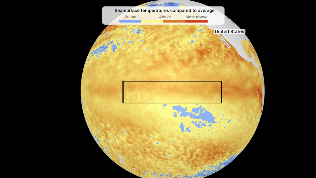
El Niño is the warm phase of the El Niño–Southern Oscillation, a natural fluctuation driven by shifts in tropical Pacific sea surface temperatures and trade winds. When those waters run significantly warmer across the central and eastern Pacific, global circulation patterns shift and remote regions feel the effects. A “strong” or “very strong” El Niño signals a larger-than-usual nudge to those patterns, raising the odds of notable weather swings worldwide.
Noaa’s phrasing — a 2 in 3 chance — is a probabilistic way of saying the conditions favor a peak event rather than a weak flicker. The Climate Prediction Center watches indicators like the Niño 3.4 sea surface temperature index and the atmosphere’s response to gauge how far this episode could run. Because forecasts always carry uncertainty, forecasters update probabilities as ocean and atmospheric data evolve toward the fall and winter months.
For the continental United States, the typical El Niño fingerprint often includes wetter-than-average conditions across parts of the southern tier, especially California, the Desert Southwest, and the Gulf Coast. That can mean increased chances for big winter storms that boost reservoirs and snowpacks in the Sierra Nevada and Rockies, but it also raises the risk of flood events and mudslides in burn-scarred terrain. The pattern is not uniform, so local effects will vary with storm tracks and timing.
At the same time, El Niño tends to suppress Atlantic hurricane activity by increasing upper-level wind shear over the tropical Atlantic, which tears apart developing storms. That doesn’t rule out landfalling systems, of course, but it often trims the seasonal tally and shifts the geographic risk balance. Meanwhile, the Pacific hurricane season can become more active, with implications for island communities and the West Coast.
Beyond storms, agriculture and water managers pay close attention to these forecasts. A strong El Niño can ease drought in some regions while exacerbating dryness in others, changing irrigation needs and planting decisions. Fisheries and coastal economies also feel it: warmer eastern Pacific waters can disrupt marine food chains, hurt anchovy and sardine populations off South America, and spark coral stress from higher temperatures.
Communities don’t have to be passive. Emergency managers, water districts, and farmers can use seasonal outlooks to adjust reservoir operations, pre-position flood-response resources, and tweak crop planning. Insurance and infrastructure planning benefit from seasonal heads-up, and public messaging can help at-risk populations prepare for potential stormier winters or altered fire seasons. The key is translating seasonal probability into practical, time-sensitive steps.
One thing to keep front of mind is uncertainty. Climate systems are noisy, and even a strong El Niño won’t produce the same outcome every time. Local geography, changing background climate conditions, and the timing of peak warmth all modulate impacts. The Climate Prediction Center will continue issuing updates, and monitoring tools like sea surface temperature anomalies and atmospheric coupling remain the best signals to watch.
If you live in an area that historically responds to El Niño — California, the Desert Southwest, the Gulf Coast, Hawaii, or parts of Central and South America — now’s the time to check seasonal plans and stay tuned to NOAA bulletins. A higher probability of a strong event doesn’t guarantee every expected outcome, but it does raise the odds enough to make planning smart and practical. Keep an eye on official updates as the season unfolds and the Pacific tells its next chapter.


