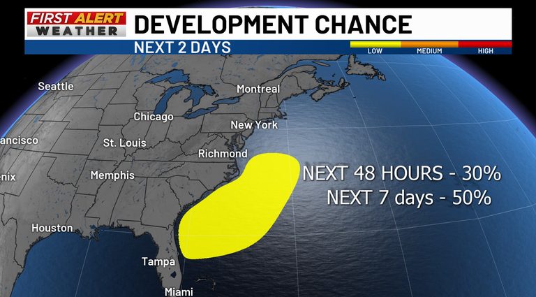
As families across the Mid‑South prepare for Thanksgiving travel, the National Hurricane Center is monitoring a broad area of low pressure near central Florida that could affect the East Coast. While the system does not need to become a named tropical storm to cause trouble, its projected path and intensity warrant caution for anyone planning to drive or fly through the region.
What the forecast shows
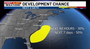
Forecasters expect the low‑pressure area to move generally north‑to‑northeast, staying near or just offshore the southeastern U.S. coast through the weekend. As it tracks, the system may acquire tropical or subtropical characteristics. The Center reports a 30% chance of development into a tropical or subtropical cyclone over the next two days, rising to 50% over the next seven days.
These percentages reflect the likelihood of the system gaining a formal designation, not the probability that any particular community will see rain, wind or flooding. Even without a name, dangerous weather—including heavy rain, strong gusts and coastal flooding—can still occur.
Immediate concerns for Florida
The National Weather Service’s Weather Prediction Center has issued a high‑risk outlook for excessive rainfall across eastern Florida. Severe flash flooding is possible, and drivers are urged never to attempt crossing a flooded road. Heavy rain could also produce dangerous surf, rip currents and gusty winds along the coastline.
Potential impacts farther north
By the weekend, the system’s rain bands may spread northward toward the Carolinas and the Mid‑Atlantic. The Hurricane Center anticipates strong, gusty winds, dangerous surf and coastal flooding along portions of the Southeast and Mid‑Atlantic coasts into early next week. The exact inland reach of the heaviest rain and strongest winds will depend on the storm’s track; a closer approach to shore could bring more severe conditions inland.
Travelers heading to the East Coast early for Thanksgiving should be aware that the greatest concern from this system is this weekend into early next week. This is an East Coast travel issue—not a forecast for the Mid‑South—and it does not guarantee bad weather on Thanksgiving Day itself.
Travel considerations
Heavy rain and flooding could slow traffic or close roads on affected routes. Gusty winds and downpours may also contribute to flight delays at East Coast airports, though it is too early to identify specific flights. Travelers with connections on the East Coast should monitor weather updates at both their connecting and final destination airports, even if conditions in Memphis appear fine.
Looking ahead
The Weather Prediction Center is also watching a separate coastal low that could develop around the middle of next week. If it forms, that system could bring another round of rain and gusty winds to the East Coast through Thanksgiving, with a chance of wintry precipitation in the Appalachians and interior Northeast on Wednesday and Thursday. Details remain uncertain, and forecasts will be refined as the holiday approaches.
For the most current information, residents and travelers should continue to check the First Alert Forecast and stay tuned to local weather updates.
Original reporting: Action News 5 WMC (Gray) — read the source article.