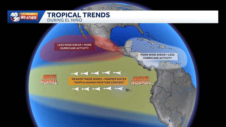
A powerful Super El Niño is developing in the equatorial Pacific Ocean, and scientists say its warming waters will influence Arkansas weather in the coming months. NOAA projects this event could become the strongest on record, with sea‑surface temperatures reaching levels not seen in centuries by December.
What a Super El Niño Means for Arkansas
The El Niño pattern occurs when trade winds weaken, allowing warm surface water to spread across the Pacific. This extra heat expands the ocean and pushes warm, moist air toward the United States. For Arkansas, the primary impact is a higher likelihood of rain across the southern third of the country, including the River Valley and Northwest Arkansas.
Historically, strong El Niños have produced very wet winters in the region. The 1982, 1997 and 2015 events all brought abundant precipitation, with the 2015 Super El Niño causing severe flooding along the Arkansas River and in Benton County. While that historic flood caused damage to businesses such as War Eagle Mill and required swift‑water rescues, the added rain also helped end long‑standing drought conditions.
Potential Benefits
For many Arkansas farmers and gardeners, the prospect of more rain is welcome. Drought‑stressed fields and reservoirs could see relief, supporting crops and livestock through the winter months. Municipal water supplies that have been running low may also benefit from increased runoff.
In addition, a wetter winter can reduce the need for costly irrigation and help restore groundwater levels that have been depleted during recent dry spells.
Risks to Watch
More rain also means a heightened risk of flooding, especially in low‑lying areas along the Arkansas River and its tributaries. Communities that experienced the 2015 flood should review local floodplain maps and consider precautionary measures such as clearing drainage ditches, securing property, and staying informed of river‑level alerts.
Coastal states are already seeing intensified king tides as warm water expands, and while Arkansas is land‑locked, the broader pattern of rising sea levels underscores the importance of preparedness for extreme weather events.
What Residents Can Do
Local emergency management agencies recommend that residents keep an eye on National Weather Service forecasts, especially during periods of heavy rain. Homeowners in flood‑prone zones should verify that their insurance policies cover water damage and consider flood‑mitigation steps such as installing sump pumps or elevating utilities.
Farmers can work with the Arkansas Department of Agriculture to access resources for drought relief and flood preparedness, ensuring that both crops and livestock are protected.
Looking Ahead
The Super El Niño is expected to peak in December and may continue to influence weather patterns into early 2027. As the Pacific warms further, scientists warn that such strong events could become more common, creating a feedback loop that accelerates global warming.
For now, Arkansans can anticipate a wetter winter that may ease drought concerns while remaining vigilant about flood risks. Staying informed and prepared will help communities navigate the dual challenges and opportunities presented by this historic climate event.
Original reporting: 40/29 News KHBS Fort Smith (local) — read the source article.