A Level 4 high‑risk flooding alert now covers the stretch from Cape Canaveral to Daytona Beach, an event that occurs on fewer than 4 % of days but accounts for the majority of flood damage and deaths, according to the Weather Prediction Center. The storm has already produced more than 15 inches of rain this week, flooding homes on the Space Coast and in Miami’s northern suburbs and forcing dozens of water rescues.
Immediate impacts in Florida
County spokesperson Don Walker told CNN that floodwater surged into “countless” homes in Brevard County on Thursday, prompting the rescue of over 100 people. In Melbourne, resident Jazmine Foster saw her home flood for the second time in two weeks, and an earlier insurance claim was denied. In the Palm Bay Estates mobile‑home park, roughly 65 units were placed under a mandatory evacuation after a bridge washed out, cutting off the only access road. Palm Bay Fire Chief Richard Stover said residents were evacuated by boat to a temporary shelter, while a voluntary evacuation advisory remains in effect for the surrounding community.
Rivers continue to rise. The St. Johns River near Cocoa surged past its 70‑year‑old record crest on Thursday, and its slow drainage means flooding could linger for weeks.
Travel disruptions expected along the East Coast
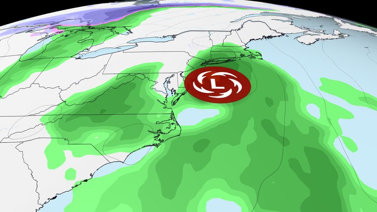
Model guidance shows the storm moving northward Saturday, bringing rain and gusty winds to coastal Georgia and the Carolinas. Airports from Jacksonville to Charleston could see delays, and beach erosion, high surf, and coastal flooding are likely.
By Sunday, the system is expected to reach the Mid‑Atlantic. Washington, D.C.’s airports may encounter rain as early as Sunday morning, though some models suggest the capital could be spared the heaviest bands. Flights from Philadelphia and New York appear clear for the morning, but afternoon gusts could cause delays.
Road travelers should anticipate slowdowns, especially on the heavily used Interstate 95 corridor from Virginia to New York City. The rain is projected to spread across New England by late Sunday evening, affecting Boston, Hartford, and Providence. While the storm’s fast forward motion should limit serious flooding, ponding on roads with poor drainage is likely.
What’s next?
Rain is expected to exit New England early Monday morning, though gusty winds may linger. Forecasts also hint at a possible secondary system that could affect the Southeast and Northeast on Wednesday into Thanksgiving Day, but details remain uncertain.
Residents in the Level 4 high‑risk zone – parts of northern Brevard and Volusia counties – should prepare for an additional 4‑8 inches of rain through early Saturday, with isolated amounts up to a foot. Local officials continue to monitor river levels and road conditions, urging anyone in flood‑prone areas to heed evacuation orders and stay informed through official channels.
Travelers planning Thanksgiving trips are advised to check airline and road updates frequently, consider alternate routes, and allow extra time for potential delays caused by the lingering effects of this storm.
Original reporting: Allentown News – 6abc Philadelphia — read the source article.