Santa Barbara County residents now have a simple way to monitor controlled fire activity after the Air Pollution Control District introduced an interactive, web‑based map. The tool, tested over the past two days, displays upcoming, active and completed prescribed burns, giving families clear visibility into when and where smoke may be present.
How the map works
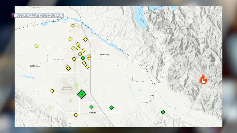
The digital interface pulls data from the district’s fire‑management partners and plots each burn on a county‑wide map. Users can click on individual projects to see details such as acreage, start and end times, and the agencies responsible for the operation. The map also includes real‑time air‑quality readings, so residents can compare smoke forecasts with actual ground‑level conditions.
Recent burns and air‑quality impact
In the past 24 hours, two large prescribed‑burn projects were carried out without any measurable impact on local air quality. East of Santa Maria, the Santa Barbara County Fire Department ignited a 260‑acre vegetation‑management burn in Tepusquet Canyon. Simultaneously, a 700‑acre burn was conducted near Alamo Creek off Highway 166 in southern San Luis Obispo County, coordinated by CAL FIRE, the San Luis Obispo Range Improvement Association and local landowners.
Although a visible plume of smoke traveled as far north as San Luis Obispo, officials reported that ground‑level air quality remained within safe limits throughout the county. The map’s live data confirmed that particulate levels stayed well below the thresholds that would trigger health advisories.
Why prescribed burns matter
Prescribed burns—controlled fires set by trained firefighters—are a proven tool for reducing the risk of catastrophic wildfires. By thinning dense vegetation and eliminating accumulated fuel, these burns create defensible space and help protect homes, schools and businesses. The practice also offers ecological benefits, such as restoring natural fire cycles and promoting healthier forest ecosystems.
The Air Pollution Control District works closely with fire agencies to manage smoke, ensuring that any emissions are minimized and that vulnerable populations—especially seniors, children and those with respiratory conditions—receive timely information. The new map is part of that effort, giving the public a transparent view of smoke‑management strategies.
What residents can do
Families are encouraged to check the map regularly, especially during the fire‑season months of fall and winter when prescribed burns are most common. If smoke is forecasted to affect a neighborhood, residents can take simple precautions: keep windows closed, use air purifiers if available, and limit outdoor activities for those with asthma or other breathing issues.
Local schools and community groups can also use the map to plan outdoor events, ensuring that children are not exposed to elevated smoke levels. The district plans to expand the tool later this year to include alerts via text and email for subscribers who want instant notifications.
Looking ahead
County officials see the interactive map as a model for other regions facing similar wildfire threats. By pairing proactive fire management with transparent communication, Santa Barbara County aims to safeguard both public health and property while preserving the natural beauty of California’s coastal landscapes.
Original reporting: KEYT (Ventura/Santa Barbara) — read the source article.